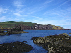
Mire Loch is a man made freshwater loch situated on St Abb's Head in the Scottish Borders, just over a kilometre NW of the village of St. Abbs at grid reference NT912687. The loch lies on land owned by the National Trust for Scotland (NTS) and is approximately 600 metres long by 50 metres at its widest point.

1. History

Mire Loch was originally an area of marshy land within the St. Abbs Head Fault. The fault separated the hard volcanic rocks of St. Abbs Head from the softer sedimentary rocks of the mainland. The glacial channel which follows the fault is marked by a distinctive inland valley across the Head which was fed by rainwater from the high ground on both sides and formed a boggy area which drained into the sea. Around the year 1900 it was decided to turn the boggy area into a recreation area. A dam was built to form a freshwater loch to be used for angling and waterfowl hunting, a nine-hole golf course was also constructed nearby. The use of the golf course was discontinued many years ago although there is some visible evidence of the old greens and tees. A boat house was built on the loch and this too has fallen into disrepair with most of the roof timbers now missing.

1. Present day

Today Mire Loch is a valued part of St. Abbs Head National Nature Reserve providing a home for freshwater birds such as little grebe, reed bunting, heron, mute swan, moorhen and sedge warbler. The fringing vegetation which is composed mostly of high reeds provides shelter and food for nesting birds as well as for migrants in spring and autumn. In early summer hundreds of herring gulls and kittiwakes bathe in the loch. In recent years the NTS has planted almost 1000 trees around the loch in an effort to provide extra cover for migrant birds. Most of these trees have been planted on the SW shore in a plantation dedicated to a diver who died off St. Abbs Head in 1981. Eels, perch and stickleback all live in the loch which is also a breeding site for frogs and toads. The loch has footpaths around its shores and walkers are encouraged by the NTS to include a circuit of the loch during their visit to St. Abb's Head although there is a warning that the paths can be quite muddy after rain. The loch has a stepped outflow which only runs for only several metres before disappearing down a man made drain, finding its way underground to the North Sea which is just 500 metres to the SE.

1. References
Nearby Places View Menu
Location Image
574 m

St Abb's Head

St Abb's Head is a rocky promontory by the village of St Abbs in Berwickshire, Scotland, and a national nature reserve administered by the National Trust for Scotland. St Abb's Head Lighthouse was designed and built by the brothers David Stevenson and Thomas Stevenson and began service on 24 February 1862.
Location Image
574 m

St Abb's Head Lighthouse

St Abb's Head Lighthouse stands on the cliffs at the rocky promontory of St Abb's Head, near the village of St Abbs in Berwickshire. A signal station was established on the cliffs before 1820 and the facilities were shared by Trinity House and Her Majesty's Coastguard. The Northern Lighthouse Board recommended the building of a lighthouse at St Abb's Head after the sinking of the Martello on Carr Rock in 1857. The lighthouse was designed and built by the brothers David Stevenson and Thomas Stevenson and assisted navigation before and after sight of the Bell Rock and Isle of May lights disappeared from view. The light began service on 24 February 1862 and initially used oil to generate its light, it was converted to incandescent power in 1906 and to electricity in 1966 and finally automated in 1993. Before automation the lighthouse was staffed by three full-time keepers whose duties included keeping detailed weather records. The lighthouse has two km of single-track tarmaced road leading to it from the main road near St Abbs village, however it is suggested by the National Trust for Scotland that it is only used by disabled visitors, and there is limited parking. Visitors can walk to the Head where the lighthouse's buildings, though still in good repair, are not open to the public. A foghorn was established at the Head in 1876, being the first audible fog signal in Scotland. The original foghorn was driven by hot air engines before being replaced by oil driven ones in 1911 and then by diesel engines in December 1955. The fog signal was discontinued in 1987 although the horn is still in place and can be reached at the edge of the cliffs by a railed path from the lighthouse.
1.5 km

St. Abbs and Eyemouth Voluntary Marine Reserve

St. Abbs and Eyemouth Voluntary Marine Reserve is a Voluntary Marine Reserve—the first established in the United Kingdom. Located in the Scottish Borders, it covers 8 kilometres of the Berwickshire coast, from Eyemouth in the south to St. Abb's Head in the north. At its centre is the fishing village of St. Abbs. The reserve is one of the most popular scuba diving locations in the United Kingdom. The water of the reserve is unusually clear, in contrast to the more silt-laden coastal waters further to the north and south. The reserve was opened on 18 August 1984 by botanist and environmental campaigner David Bellamy.
Location Image
1.6 km

St Abbs Lifeboat Station

St Abbs Lifeboat is an independent voluntary search and rescue lifeboat service based in the village of St Abbs, located on the southeast coast of Scotland in the Scottish Borders. St Abbs lifeboat station has been operational since 1911, providing search and rescue cover along the Berwickshire coastline and out into the North Sea. Since 2015, it has been operated by an independent charity following the withdrawal of support from the Royal National Lifeboat Institution (RNLI). This means the community and crew are responsible for all aspects of running the station, including governance, fundraising, training, and maintenance. The lifeboat station and lifeboat shop are run entirely by unpaid volunteers. St Abbs Lifeboat Station holds "Declared Facility Status" (DFS), a standard set by the Maritime & Coastguard Agency (MCA), qualifying the station to participate in the UK Coastguard's Search and Rescue (SAR) service. The station currently operates the inshore lifeboat Thomas Tunnock. She is one of the fastest lifeboats in the UK, with a maximum speed of 40 knots. This enables the crew, who are on call 24 hours a day, 365 days a year, to respond swiftly to anyone in need of assistance along the Berwickshire coast.