
 English
 Français

Bowfell (named Bow Fell on Ordnance Survey maps) is a pyramid-shaped mountain lying at the heart of the English Lake District, in the Southern Fells area. It is the eighth-highest mountain in the Lake District and one of the most popular of the Lake District fells for walkers. It is listed in Alfred Wainwright's 'best half dozen' Lake District fells.
Nearby Places View Menu
1.2 km
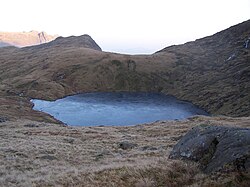
Angle Tarn (Langstrath)
Angle Tarn is a tarn to the north of Bowfell in the English Lake District. It drains into Langstrath Beck.
This should not be confused with Angle Tarn (Patterdale), a larger lake with the same name about 11.5 miles (18.5 km) to the south-west, also within the Lake District National Park.

1.3 km
Rossett Pike
Rossett Pike is a fell in the English Lake District. It is located at the head of Mickleden, one of two tributary valleys of Great Langdale.


1.7 km
Crinkle Crags
Crinkle Crags is a fell in the English Lake District in the county of Cumbria. It forms part of two major rings of mountains, surrounding the valleys of Great Langdale and Upper Eskdale. The name reflects the fell's physical appearance as its summit ridge is a series of five rises and depressions (crinkles) that are very distinctive from the valley floor. In Old English, cringol means twisted or wrinkled.