
 English
 Français

Halton (Northumberland)
Halton est une ancienne paroisse civile et un village du Northumberland, en Angleterre.
1. Notes et références
(en) Cet article est partiellement ou en totalité issu de l’article de Wikipédia en anglais intitulé « Halton, Northumberland » (voir la liste des auteurs).
1. Liens externes
Portail de l’Angleterre
Nearby Places View Menu
0 m
Halton, Northumberland
Halton is a village and former civil parish, now in the parish of Whittington, in the southern part of Northumberland, England. It is situated 3 miles (4.8 km) north of Corbridge just south of Hadrian's Wall. In 1951 the parish had a population of 24.
Halton Castle is a pele tower and grade I listed building.
169 m
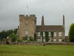
Halton Castle, Northumberland
Halton Castle is a pele tower and grade I listed building situated close to Hadrian's Wall to the north of the village of Corbridge in Northumberland, England.
The tower was first recorded in 1382 and it is still present today. It has four storeys and a basement with a stone vault. In the 15th century a manor house was built onto the north side of the tower giving it a T-shaped plan. In about 1696 much of this building was demolished by the then owner John Douglas and replaced with the present five-bay residence.
In 1757 Anne Douglas the heiress of Halton married Sir Edward Blackett and the castle remains a residence of the Blackett family.

1.3 km
Milecastle 22
Milecastle 22 (Portgate) was a milecastle of the Roman Hadrian's Wall. Its remains exist as a low, turf covered platform just east of the Portgate roundabout (junction of the A68 and B6318). The platform is 0.5 metres (1.6 ft) on the east side, reducing to only a parch mark on the west side.

1.4 km
Aydon Castle
Aydon Castle, previously sometimes called Aydon Hall, is a fortified manor house at Aydon near to the town of Corbridge, Northumberland, England. It is a Scheduled Ancient Monument, and is designated by English Heritage as a Grade I listed building.
1.5 km
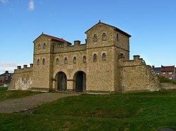
Portgate
The Portgate was a fortified gateway, constructed as part of Hadrian's Wall where it crossed the Roman road now known as Dere Street, which preceded Hadrian's Wall by around 50 years. It was built to control traffic along Dere Street as it passed north through Hadrian's Wall. The gate's remains exist beneath the old B6318 Military Road to the south-west of the Stagshaw Roundabout (the B6318 was diverted slightly for the construction of the Stagshaw Roundabout, leaving two short sections of the existing road unlinked – the remains of the Portgate are buried beneath the western section).