
 English
 Français

Buckden (Yorkshire du Nord)
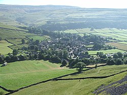
Buckden est un village et une paroisse civile du Yorkshire du Nord, en Angleterre. Historiquement rattaché au West Riding of Yorkshire, Buckden se trouve dans le parc national des Yorkshire Dales, sur la rive est de la Wharfe, qui coule dans la vallée du même nom. La paroisse civile de Buckden inclut également le hameau de Cray ainsi que la totalité de la vallée de Langstroth. D'après le recensement de 2011, la paroisse compte 187 habitants.
Nearby Places View Menu
0 m
Buckden, North Yorkshire
Buckden is a village and civil parish in the county of North Yorkshire, England. Historically part of the West Riding of Yorkshire, Buckden is situated in the Yorkshire Dales National Park, and on the east bank of the River Wharfe in Wharfedale. The civil parish includes the hamlet of Cray and the whole of Langstrothdale. According to the 2011 Census the parish had a population of 187.

2.5 km
Buckden Pike
Buckden Pike is a fell at the head of Wharfedale, a valley in the Yorkshire Dales, that stands above the village of Buckden, England. At 702 metres (2,303 ft), it narrowly misses out on being the highest peak in the area, the title instead going to nearby Great Whernside (704 metres). The summit is marked by a trig point.

2.9 km
Starbotton
Starbotton is a village of around 60 houses in Upper Wharfedale in the county of North Yorkshire, England. It is situated in the Yorkshire Dales National Park, by the River Wharfe. The resident population is around 48 and many village houses are used for holiday accommodation. There are two working farms - one at either end of the village, the rest having been converted for other uses. The village is on the opposite bank of the Wharfe to the Dales Way halfway between Kettlewell and Buckden.
Until 1974 it was part of the West Riding of Yorkshire. From 1974 to 2023 it was part of the district of Craven, it is now administered by the unitary North Yorkshire Council.
4.1 km
Kettlewell with Starbotton
Kettlewell with Starbotton is a civil parish in the county of North Yorkshire, England.
Kettlewell is a village in Upper Wharfedale, North Yorkshire, England. It lies between the villages of Grassington, Kilnsey and Conistone to the south, Starbotton to the northwest, the hamlet of Horsehouse to the northeast, and later on Coverdale. Kettlewell nestles at the feet of Great Whernside, and Buckden Pike, where Park Gill Beck joins the River Wharfe, and set to the east of the Wharfe. Both river and beck are joined by attractive stone bridges there.
Starbotton is a hamlet of around 70 houses situated in the Yorkshire Dales National Park, by the River Wharfe in Wharfedale. The resident population is only around 75 with many of the village houses being used as holiday accommodation. There are only two remaining working farms - one at either end of the village, the rest having been converted in one way or another. It is on the opposite bank of the River Wharfe to the Dales Way halfway between Kettlewell and Buckden.
Until 1974 it was part of the West Riding of Yorkshire. From 1974 to 2023 it was part of the district of Craven, it is now administered by the unitary North Yorkshire Council.

4.4 km
Kettlewell Meadows
Kettlewell Meadows is a Site of Special Scientific Interest (SSSI) within Yorkshire Dales National Park, in North Yorkshire, England. It is located in Wharfedale between the villages of Starbotton and Kettlewell. It is protected because of the botanically rich floodplain grassland maintained by a traditional management regime. The long-distance footpath called the Dales Way passes through this protected area.
Kettlewell Meadows is adjacent to another protected area called River Wharfe SSSI.