
 English
 Français

Buckden Pike
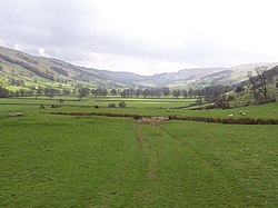
Buckden Pike is a fell at the head of Wharfedale, a valley in the Yorkshire Dales, that stands above the village of Buckden, England. At 702 metres (2,303 ft), it narrowly misses out on being the highest peak in the area, the title instead going to nearby Great Whernside (704 metres). The summit is marked by a trig point.
Nearby Places View Menu

2.5 km
Buckden, North Yorkshire
Buckden is a village and civil parish in the county of North Yorkshire, England. Historically part of the West Riding of Yorkshire, Buckden is situated in the Yorkshire Dales National Park, and on the east bank of the River Wharfe in Wharfedale. The civil parish includes the hamlet of Cray and the whole of Langstrothdale. According to the 2011 Census the parish had a population of 187.
3.1 km
Bishopdale, North Yorkshire
Bishopdale is a dale in the Yorkshire Dales National Park in North Yorkshire, England. The dale is a side dale on the south side of Wensleydale, and extends for some 6 miles (10 km) south west from Aysgarth. Bishopdale is also the name of a civil parish, which includes only the sparsely populated upper reaches of the dale, from the head of the dale as far downstream as Howesyke and Howgill Gill.

4.1 km
Starbotton
Starbotton is a village of around 60 houses in Upper Wharfedale in the county of North Yorkshire, England. It is situated in the Yorkshire Dales National Park, by the River Wharfe. The resident population is around 48 and many village houses are used for holiday accommodation. There are two working farms - one at either end of the village, the rest having been converted for other uses. The village is on the opposite bank of the Wharfe to the Dales Way halfway between Kettlewell and Buckden.
Until 1974 it was part of the West Riding of Yorkshire. From 1974 to 2023 it was part of the district of Craven, it is now administered by the unitary North Yorkshire Council.

4.1 km
Smelter Farmhouse
Smelter Farmhouse is a historic building in Bishopdale, North Yorkshire, a valley in England.
Smelter is the second farm from the top of Bishopdale. The farmhouse is dated 1701, and was probably built for John Horner. A Mediaeval hearth has been found on the hillside nearby, and the building's name is probably a reference to this. In 1908, it was described as "a quaint-looking structure", and was the house of the local gameskeeper. It was Grade II* listed in 1969, but was uninhabited for a time later in the century.
The farmhouse is in stone with quoins, and a stone slate roof with stone coping and shaped kneelers. There are two storeys and an irregular U-shaped plan, with a front range of three bays, a rear wing on the left, and a shorter staircase wing on the right. The central doorway has an elaborately moulded surround, the inner moulding forming a stepped head with the date and initials on the spandrels. Above is a pulvinated frieze and a segmental pediment. The window over the doorway has a single light with a stepped head, there is an oval fire window, and elsewhere are double-chamfered mullioned windows, some with segmental-arched lights, and some with hood moulds.