
 English
 Français
Bishopdale, North Yorkshire
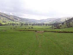
Bishopdale is a dale in the Yorkshire Dales National Park in North Yorkshire, England. The dale is a side dale on the south side of Wensleydale, and extends for some 6 miles (10 km) south west from Aysgarth. Bishopdale is also the name of a civil parish, which includes only the sparsely populated upper reaches of the dale, from the head of the dale as far downstream as Howesyke and Howgill Gill.
Nearby Places View Menu

1.3 km
Smelter Farmhouse
Smelter Farmhouse is a historic building in Bishopdale, North Yorkshire, a valley in England.
Smelter is the second farm from the top of Bishopdale. The farmhouse is dated 1701, and was probably built for John Horner. A Mediaeval hearth has been found on the hillside nearby, and the building's name is probably a reference to this. In 1908, it was described as "a quaint-looking structure", and was the house of the local gameskeeper. It was Grade II* listed in 1969, but was uninhabited for a time later in the century.
The farmhouse is in stone with quoins, and a stone slate roof with stone coping and shaped kneelers. There are two storeys and an irregular U-shaped plan, with a front range of three bays, a rear wing on the left, and a shorter staircase wing on the right. The central doorway has an elaborately moulded surround, the inner moulding forming a stepped head with the date and initials on the spandrels. Above is a pulvinated frieze and a segmental pediment. The window over the doorway has a single light with a stepped head, there is an oval fire window, and elsewhere are double-chamfered mullioned windows, some with segmental-arched lights, and some with hood moulds.
1.4 km
Longridge Farmhouse
Longridge Farmhouse is a historic building in Bishopdale, North Yorkshire, a valley in England.
The farmhouse was built for George and Elizabeth Dodsworth, and is dated 1653, although its kitchen may be older. The building was Grade II* listed in 1969, along with its outbuilding, which appears to have originally been part of the house, and has been converted into a garage. The farm is a long-term tenancy, and was sold in 1997 for £125,000.
Nikolaus Pevsner simply describes the building as "good", while Yorkshire Life praises its "two-storeyed porch and other fine details".
The farmhouse and outbuilding to the left are in stone with a string course and a stone slate roof. There are two storeys, three bays, and a rear outshut. The middle bay projects as a two-storey gabled porch containing a doorway with a quoined surround, a moulded arris and a triangular head, over which is an initialled and dated inscription. The inner doorway has a similar inscription on sunken spandrels. On the returns of the porch are round-headed windows with a chamfered surround, and elsewhere are double-chamfered mullioned windows, some with hood moulds. Inside, there is a large fireplace with a pointed arch with a salt box and a beehive oven, a triangular-headed fireplace in the parlour, and various exposed beams.

3.1 km
Buckden Pike
Buckden Pike is a fell at the head of Wharfedale, a valley in the Yorkshire Dales, that stands above the village of Buckden, England. At 702 metres (2,303 ft), it narrowly misses out on being the highest peak in the area, the title instead going to nearby Great Whernside (704 metres). The summit is marked by a trig point.
4.0 km
Yorkshire Dales
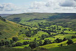
The Yorkshire Dales are a series of valleys, or dales, in the Pennines, an upland range in England. They are mostly located in the ceremonial county of North Yorkshire, but extend into Cumbria and Lancashire; they are entirely within the historic boundaries of Yorkshire. The majority of the dales are within the Yorkshire Dales National Park, created in 1954. The exception is the area around Nidderdale, which forms the separate Nidderdale Area of Outstanding Natural Beauty.
The landscape of the Yorkshire Dales consists of sheltered glacial valleys separated by exposed moorland. The predominant rock is Carboniferous Limestone, which is particularly visible in the south-west in features such as Malham Cove. It is overlain in many areas by the Yoredale Series of alternating weak shales and hard limestones and sandstones, which give the dales their characteristic 'stepped' appearance. Most of the dales contain rivers, and the area contains seven primary catchments: the Swale, Ure, Wharfe, Aire, Nidd, Ribble, and Lune. There are several notable cave systems in the area, including part of the longest system in the United Kingdom, the Three Counties.
Agriculture and other land management has significantly affected the appearance of the Dales, through the creation of pastures and meadows for livestock grazing and moorland for red grouse shooting. Dry stone walls and field barns are characteristic of the valley floors, particularly Wensleydale and Swaledale in the north. Wensleydale cheese is a particularly famous product from the region. The dales are popular for hiking, and are crossed by the Dales Way, Pennine Way, and Coast to Coast long-distance footpaths. The Yorkshire Three Peaks is a walking trail entirely within the area which takes in three of its mountains: Ingleborough (723 m (2,372 ft)), Whernside (736 m (2,415 ft)), and Pen-y-ghent (694 m (2,277 ft)). The extensive cave systems are a major centre for caving in the UK.