
 English
 Français

Wallingfen railway station was a station on the Hull and Barnsley Railway, and served the village of Newport in the East Riding of Yorkshire, England. The station opened on 27 July 1885 as Newport for goods traffic, and a week later it opened to passengers. It was renamed Newport (Yorks) in September 1921 and on 1 July 1923 to Wallingfen to avoid confusion with others stations titled Newport. It closed to passengers on 1 August 1955 and closed completely on 6 April 1959. The station has been demolished, and a section of the M62 motorway was built over the railway alignment in the 1970s.
Nearby Places View Menu
794 m
Newport, East Riding of Yorkshire
Newport is a village and civil parish in the East Riding of Yorkshire, England. It is approximately 7 miles (11 km) east of the market town of Howden. It lies on the B1230 road to the south of the M62 motorway and on the banks of the Market Weighton Canal.
According to the 2011 UK census, Newport parish had a population of 1,580, an increase on the 2001 UK census figure of 1,538.
Newport has a church, a school, a few shops, three public houses and two playing fields.
In 1823 Newport (then New Port with New Village, and the 'West Side' of the settlement), was partly in the parish of Eastrington, partly part of an extra-parochial area, and within the Wapentake and Liberty of Howdenshire, and the Wapentake of Harthill. In the early 1770s the area that became Newport was the uncultivated and barren Walling Fen. A clay bed 30 feet (9 m) deep, and adjacent to the present village, was found and dug to provide material for the production of bricks, tiles and earthenware. A quantity of 1,700,000 tiles and 2,000,000 bricks were being made annually by 1823. The village that had grown over 50 years attained a population of 339 and a Wesleyan chapel, established 1814, with Sunday School to educate 200 poor children for Newport and surrounding villages. Occupations in 1823 for Newport, New Village and West Side, included nine farmers, two blacksmiths, seven brick and tile manufacturers, an earthenware manufacturer, two butchers, two carpenters, two coal merchants, three corn millers, five drapers, one of whom was a druggist, three grocers, two saddlers, two shoemakers, five tailors, eight master mariners, a bricklayer, a hair dresser, a sacking weaver & basket maker, two shopkeepers, a baker, a gardener, a schoolmaster, and the landlords of The Turk's Head, The King's Arms Inn, and The Crown & Anchor public houses. A packet boat conveyed goods and passengers by water to Hull and back once a week. A carrier conveyed goods and passengers by land to Hull, and to Howden, once a week. A mail coach ran to Hull and Doncaster daily.
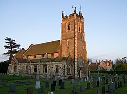
The 1897–98 Newport parish church of St Stephen was designated a Grade II listed building in 1987.
Newport was served by Wallingfen railway station, formerly Newport, on the Hull and Barnsley Railway between 1885 and 1955.

1.6 km
Scalby, East Riding of Yorkshire
Scalby is a hamlet in the civil parish of Gilberdyke, in the East Riding of Yorkshire, England. It is situated approximately 7 miles (11 km) west of Brough and 7 miles (11 km) north-east of Goole. It lies on the B1230 road.
Historically in the wapentake of Howdenshire, it is now represented at Parliament as part of the Goole and Pocklington constituency.
The name is from the same form as Scalby in North Yorkshire; Skalle-by, with Skalle being a personal name. Skalle is Old Norse and by means farm or farmstead.
Scalby was formerly a township in the parish of Blacktoft, in 1866 Scalby became a separate civil parish, on 1 April 1935 the parish was abolished and merged with Blacktoft, part also went to form Gilberdyke and Newport. In 1931 the parish had a population of 160.

1.8 km
River Foulness
The River Foulness is a river in the East Riding of Yorkshire, England. Its name is derived from Old English fūle[n] ēa, meaning “dirty water”. Maintenance responsibilities for the river transferred from the Environment Agency to the Market Weighton Drainage Board on 1 October 2011. Market Weighton Drainage Board subsequently amalgamated with the Lower Ouse Internal Drainage Board on 1 April 2012 to create the Ouse and Humber Drainage Board. The river discharges into the Humber Estuary via Market Weighton Canal. Water levels within the river, its tributaries and the canal are managed and controlled by the Environment Agency. The river lies in an area known as the Humberhead Levels.
2.0 km
Sandholme railway station
Sandholme railway station was a station on the Hull and Barnsley Railway, and served the hamlet of Sandholme in the East Riding of Yorkshire, England.
The station opened on 27 July 1885, it was closed to passengers on 1 August 1955 and closed completely on 6 April 1959.