
 English
 Français
Galava
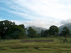
Galava, aussi appelé le fort romain d’Ambleside, est un ancien camp romain de la province de Britannia, situé aujourd'hui au nord du lac Windermere, dans le village britannique de Waterhead (en), non loin d'Ambleside, dans le comté anglais de Cumbria (anciennement, dans le Westmorland). Il date du Ier ou IIe siècle. Il gardait la route romaine entre Brocavum (à Brougham) et Glannoventa (à Ravenglass). Le domaine de Borrans, où se situe le camp romain, fait aujourd’hui partie des propriétés de l'English Heritage et est géré par le National Trust.
Nearby Places View Menu
101 m
Ambleside Roman Fort
Ambleside Roman Fort is the modern name given to the remains of a fort of the Roman province of Britannia. The ruins have been tentatively identified as those of either Galava or Clanoventa, mentioned in the Antonine Itinerary. Dating to the 1st or 2nd century AD, its ruins are located on the northern shore of Windermere at Waterhead, near Ambleside, in the English county of Cumbria, within the boundaries of the Lake District National Park.
The fort guarded the Roman road from Brougham to the Roman fort of Glannoventa by the sea at Ravenglass, by way of Hardknott Roman Fort. There is also assumed to have been a road south to the fort at Kendal. In 2016 it was reported that LIDAR technology had revealed a Roman road running north from Ambleside fort to Carlisle, and another running northwest to Papcastle. These roads had been previously described by John Horsley in his Britannia Romana of 1732.
The ruins are a Grade I listed structure. The site is open to the public, and is owned and managed by the National Trust. The site is a scheduled monument with list entry numbers of 1009348 and 1244785 (formerly RSM 13567 and RBS 450573)
396 m
Rothay Manor
Rothay Manor is a country house near Ambleside in Cumbria. It is a Grade II listed building.

594 m
Clappersgate
Clappersgate is a village in the Westmorland and Furness Unitary Authority, in the county of Cumbria, England. Clappersgate is located on the B5286 road and on the River Brathay. It is near the town of Ambleside and downstream of Elterwater and Chapel Stile.
The village was once home to a stone skimming club known as the Slate Slingers who utilised the slate washed downstream from quarries, and the large pool located under Clappersgate Bridge.

635 m
Brathay
Brathay is a hamlet in Skelwith parish in Cumbria, England. Historically part of Lancashire, the hamlet lies close to Clappersgate on the south bank of the River Brathay, and is about 0.9 miles (1.5 km) south west of Ambleside.
Brathay Hall is a country house from the late 18th century. The house and the surrounding estate belong to a charity, the Brathay Trust.

838 m
Ambleside
Ambleside is a town in the civil parish of Lakes and the Westmorland and Furness district of Cumbria, England. Within the boundaries of the historic county of Westmorland and located in the Lake District National Park, the town sits at the head of Windermere, England's largest natural lake. In 2022 the built up area had an estimated population of 2,586.