
 English
 Français

A666 road
The A666 is a major road in Greater Manchester and Lancashire, England.
Nearby Places View Menu

1.3 km
Cheetham Close
Cheetham Close is a megalithic site and scheduled ancient monument located in Lancashire, very close to the boundary with Greater Manchester, England. The megalith was in good condition until a farmer from Turton sledgehammered the circle in the 1870s. According to an article published in 1829, Cheetham Close was once a druidical ritual place and a Roman road passed 'within two hundred yards' of the megalith.
The stone circle at Cheetham Close measured about 18.5 metres (61 ft) in diameter. Six stones are definitely part of the circle and other smaller stones are scattered about the place. The monument has been damaged, and the stones fractured.

1.7 km
Yarnsdale
Yarnsdale is a dale or valley in Lancashire. The name is derived from the heron or hern.
It contains a small sandstone quarry, also known as Cadshaw Quarry at grid reference 706.178, situated to the north west of Turton and Entwistle Reservoir in the borough of Blackburn with Darwen. It is used mainly by rock climbers and hikers who use it as a short cut between Turton Moor and the reservoir, passing the Strawbury Duck Hotel, (known for Black Sheep bitter), at Entwistle. There is a station on the East Lancashire Railway line at Entwistle. Yarnsdale contains Fairy Battery – an outcrop of rock popular with climbers. The site was the secret meeting place of non-conformist worshippers in the 17th century. Opposite the outcrop on the other side of Cadshaw Brook is a quarry complex with extensive mine caverns, now filled in. The Witton Weavers Way long-distance path passes close to the north.
1.9 km
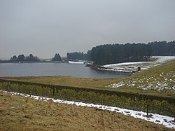
Dingle Reservoir
Dingle Reservoir is an artificial, low alkalinity, shallow reservoir near the town of Egerton, Greater Manchester. It is a little under 400 metres from the border between Lancashire and Greater Manchester, on the Lancashire side.

2.0 km
Egerton, Greater Manchester
Egerton, (pronounced "edgerton"), is a village in the northern part of the Metropolitan Borough of Bolton, Greater Manchester, England. Historically a part of Lancashire, it is situated three miles north of Bolton and 12 miles north west of Manchester city centre within the West Pennine Moors.
Egerton was originally part of the township of Turton in the ancient parish of Bolton-le-Moors and consisted of a small, remote, farming community known as Walmsley. The name Egerton was brought to the area in 1663 when Ralph Egerton married the step-daughter of James Walmsley, after which their property became known as Egerton's. The village developed in the 1830s when Henry and Edmund Ashworth set up cotton mills. Egerton formed part of the Turton Urban District in Lancashire between 1894 and 1974, when the district was abolished. The more urban southern part of the district, including Egerton, was then transferred to Bolton in Greater Manchester.
The village is a commuter suburb for Bolton, Blackburn and Manchester.
Egerton is located a short distance from Bromley Cross and Tonge Moor, close to Canon Slade School in Bradshaw and Turton School.
Parts of Egerton were designated a conservation area by Bolton Council in 1981 to protect the character of the village. The conservation area contains a wide variety of buildings dating from the early 19th Century to the present day. It contains two Grade II listed buildings, and comprises frontages to the Blackburn Road (A666) and a number of side streets, Egerton Cricket Ground, Egerton Park, the grounds of Egerton House and Christ Church.
To the west of Egerton is Gale Clough and Shooterslee Wood, a Site of Special Scientific Interest designated for its biological interest. The site is 8.6 hectares (21 acres) and is important due to its broad-leaved woodland which is among the most important in Greater Manchester.
Egerton was the birthplace of Bolton Wanderers F.C., which started there as Christ Church F.C. in 1874.