
 English
 Français

North Frodingham
North Frodingham est une paroisse civile et un village du Yorkshire de l'Est, en Angleterre.
1. Notes et références
(en) Cet article est partiellement ou en totalité issu de l’article de Wikipédia en anglais intitulé « North Frodingham » (voir la liste des auteurs).
1. Liens externes
Ressource relative à la géographie : Open Domesday
Portail du Yorkshire
Nearby Places View Menu
0 m
North Frodingham
North Frodingham is a village and civil parish in the East Riding of Yorkshire, England. It is situated approximately 5.5 miles (9 km) south-east of the town of Driffield and lies on the B1249 road.
The civil parish is formed by the village of North Frodingham and the hamlets of Church End and Emmotland.
According to the 2011 UK census, North Frodingham parish had a population of 830, an increase on the 2001 UK census figure of 712.
The name Frodingham derives from the Old English Frodaingashām or Frodainghām, meaning 'settlement of Froda's people' or 'settlement at Froda's place'.
The Grade II* listed church of St Elgin, North Frodingham was restored in stages between 1877 and 1891 by Sir Tatton Sykes, 5th Baronet with the top part of the perpendicular tower being designed by Temple Moor in 1892. It is on the Sykes Churches Trail devised by the East Yorkshire Churches Group.
In 1901 there was a proposal to construct a railway terminus as part of the North Holderness Light Railway, but despite appearing on the North Eastern Railway's tile maps at various stations (including Beverley), the line was never constructed.
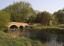
The Old Howe and North Frodingham beck join to the west of the village. The landing was used until the 1950s for unloading coal transported from Kingston upon Hull.
In 1823 North Frodingham was a town and civil parish in the Wapentake and Liberty of Holderness. Baines states that a town market was in disuse because of falling population, its charter having been transferred to the more successful town of Driffield in the 1860s. There were three chapels; one for Methodists, one for Independents, and one for Ranters. Population at the time was 575, including that of Emmotland. Occupations included twenty-two farmers, three blacksmiths, three grocers, one of whom was also a draper, three shoemakers, two tailors, two wheelwrights, two bricklayers, a weaver, a twine maker, a straw hat manufacturer, a plumber & glazier, a book keeper, a schoolmaster, and the landlords of The Red Line, The Star Inn, and The Gate public houses. Two carriers operated between the town and Driffield, and Beverley, once a week. Once a fortnight a further carrier linked North Frodingham by water to Hull.
North Frodingham has one public house, the Blue Post Inn. There is a small park overlooking a social centre. The village is surrounded by fields and farms.
There is a village store (The Post Office) and a carpet shop. The village has a bus stop, but the public transportation options in the area are limited, so most people travel by car.

475 m
North Holderness Light Railway
The North Holderness Light Railway was a proposed light railway, which was to have been constructed by the North Eastern Railway (NER) between Beverley and North Frodingham, in the East Riding of Yorkshire, England. The scheme was given parliamentary approval in September 1898 (under the Light Railways Act) for a line extending to 12.5 miles (20.1 km).
The line would have begun from a junction with the Hull to Scarborough Line, slightly to the north of Beverley railway station, and served villages and agricultural land in the Holderness area. Stations were proposed at Tickton, Routh, Long Riston, Leven, Brandesburton and North Frodingham. At North Frodingham the line would have shared a station with a separate light railway, the Bridlington and North Frodingham (also never built), running to Carnaby on the Hull to Scarborough Line.
The NER abandoned the plans for the North Holderness line in 1903 and a bus service was provided instead, connecting Beverley to North Frodingham and then continuing to Driffield. Buses began running on 7 September 1903 and the route was the second bus service to be operated by a British railway company. The service continued to be run by the NER and its successor, the London and North Eastern Railway, until 1933 when it was sold to a local bus company.
Plans for a railway were later reconsidered, though with the line built to a narrower gauge than standard gauge on account of some of the marshy land that the line would have to cross, and in 1919 Darlington Works designed a 2 ft (610 mm) gauge tank locomotive.
The route was shown on tiled maps of the North Eastern Railway network at some of their stations. These maps are still extant at Beverley, Hartlepool, Middlesbrough, Saltburn, Scarborough, Tynemouth, Whitby and York. An example can also be seen at the National Railway Museum.

1.1 km
Church End, East Riding of Yorkshire
Church End is a hamlet in the East Riding of Yorkshire, England. It is situated approximately 1 mile (1.6 km) west of the village of North Frodingham on the B1249 road.
It forms part of the civil parish of North Frodingham.
The Grade II* listed church of St Elgin was restored in stages between 1877 and 1891 by Sir Tatton Sykes, 5th Baronet with the top part of the Perpendicular tower being designed by Temple Moor in 1892. It is on the Sykes Churches Trail devised by the East Yorkshire Churches Group.

1.9 km
Fisholme
Fisholme is a small area in the East Riding of Yorkshire, England that is situated between Brigham and Emmotland. The canal section of the Driffield Navigation leaves Frodingham Beck at this point. The name derives from Old English and means the water-meadow near where the fish were caught.
2.1 km
West Beck
West Beck is the common name given to the upper section of the old River Hull, as it rises in the foothills of the Yorkshire Wolds. After reaching Frodingham Beck at Emmotland, it becomes called the River Hull. It is noteworthy for being the most northerly chalk stream in England. It provides fly fishing for wild brown trout and grayling.