
 English
 Français

Stonethwaite Beck is a minor river in Cumbria, England. It is a tributary of the River Derwent. Stonethwaite Beck is formed at the confluence of Langstrath Beck and Greenup Gill beneath Eagle Crag, at Smithymire Island. It continues north west and north through Galleny Force, past the villages of Stonethwaite and Rosthwaite, flowing into the Derwent in Borrowdale.
Nearby Places View Menu
315 m
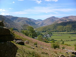
Borrowdale
Borrowdale is a valley and civil parish in the English Lake District in Cumberland, England. It is in the ceremonial county of Cumbria, and is sometimes referred to as Cumberland Borrowdale to distinguish it from another Borrowdale in the historic county of Westmorland.

663 m
Castle Crag
Castle Crag is a hill in the North Western Fells of the English Lake District. It is the smallest hill included in Alfred Wainwright's influential Pictorial Guide to the Lakeland Fells, the only Wainwright below 1,000 feet (300 m).
Wainwright accorded Castle Crag the status of a separate fell because it "is so magnificently independent, so ruggedly individual, so aggressively unashamed of its lack of inches, that less than justice would be done by relegating it to a paragraph in the High Spy chapter." Subsequent guidebooks have not always agreed: Castle Crag is one of only two Wainwrights not included in Bill Birkett's Complete Lakeland Fells.
757 m
Rosthwaite, Borrowdale
Rosthwaite is a settlement in the Borrowdale parish of Cumberland, Cumbria, England. It is also in Borrowdale in the English Lake District to the south of Derwent Water. The B5289 road goes through the settlement and it is to the east of the Honister Pass.
Historically part of Cumberland, the nearest town to Rosthwaite is Keswick, which is situated approximately 6 miles (9.7 km) to the north.

1.0 km
Bowder Stone
The Bowder Stone is a large andesite lava boulder, that fell 200 metres (660 ft) from the Bowder Crag on Kings How between 13,500 and 10,000 years ago. The stone is situated in Borrowdale, Cumbria, England, at grid reference NY25401639. It is estimated to weigh around 2000 tons and is about 30 feet (9.1 m) high, 50 feet (15 m) across and 90 feet (27 m) in circumference. There is a staircase allowing visitors to climb to the top, and has been since at least 1890.