
 English
 Français

Pennines
Les Pennines sont une chaîne de montagnes du Royaume-Uni située dans le centre et le nord de l'Angleterre. De par son extension nord-sud, sa position centrale dans la Grande-Bretagne et constituant le seul relief vraiment étendu de l'Angleterre, elle est surnommée « la colonne vertébrale de l'Angleterre », en anglais the backbone of England. Son nom est issu du celtique penno qui signifie « tête » > « sommet ».
Nearby Places View Menu
36 m
Pennines
The Pennines (), also known as the Pennine Chain or Pennine Hills, are an upland range mainly located in Northern England. Sometimes described as the "backbone of England" because of its length and position, the range runs from Derbyshire and Staffordshire in the north of the Midlands to Northumberland in North East England. From the Tyne Gap in the north, the range extends south through the North Pennines, Yorkshire Dales, South Pennines, and Peak District to end near the valley of the River Trent. The Border Moors and Cheviot Hills, which lie beyond the Tyne Gap, are included in some definitions of the range.
The range is divided into two by the Aire Gap, a wide pass formed by the valleys of the rivers Aire and Ribble. There are several spurs off the main Pennine range east into Greater Manchester and Lancashire, comprising the Rossendale Fells, West Pennine Moors, and Bowland Fells. The Howgill Fells and Orton Fells in Cumbria are also sometimes considered to be Pennine spurs. The Pennines are an important water catchment area, with numerous reservoirs in the head streams of the river valleys.
Most of the range is protected by national parks and national landscapes (formerly Areas of Outstanding Natural Beauty). Running north to south, and including the Cheviots, the range is within Northumberland National Park, the North Pennines National Landscape, the Yorkshire Dales National Park, Nidderdale National Landscape, the Forest of Bowland National Landscape, and the Peak District National Park. The only significant unprotected area is that between Skipton and Marsden.
Britain's oldest long-distance footpath, the 268-mile (429 km) Pennine Way, runs along most of the Pennines.
36 m
Cross Fell
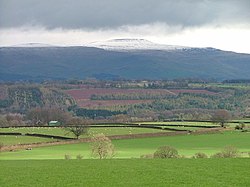
Cross Fell is the highest mountain in the Pennines of Northern England and the highest point in England outside the Lake District. It is located in the North Pennines Area of Outstanding Natural Beauty. It lies within the county of Cumbria and the historic county boundaries of Cumberland.
The summit, at 893 metres (2,930 ft), is a stony plateau, part of a 7+3⁄4-mile-long (12.5-kilometre) ridge running north-west to south-east, which also incorporates Little Dun Fell at 842 metres (2,762 ft) and Great Dun Fell at 848 metres (2,782 ft). The three adjoining fells form an escarpment that rises steeply above the Eden Valley on its south-western side and drops off more gently on its north-eastern side towards the South Tyne and Tees Valleys.
Cross Fell summit is crowned by a cross-shaped dry-stone shelter. On a clear day there are excellent views from the summit across the Eden Valley to the mountains of the Lake District. On the northern side of Cross Fell there are also fine views across the Solway Firth to the Southern Uplands of Scotland.
The fell is prone to dense hill fog and fierce winds. A shrieking noise induced by the Helm Wind is a characteristic of the locality. It can be an inhospitable place for much of the year. In ancient times it was known as "Fiends Fell" and believed to be the haunt of evil spirits. St Augustine of Canterbury is said to have blessed the hill when he arrived here on his travels so it became known as Cross Fell in the Christian tradition, although it has been speculated that the fell became known as Cross Fell ("cross" meaning "angry") because of the evil spirits.
The fell is home to a mountain bothy (Greg's hut) which is located approximately 3⁄4 mile (1.2 kilometres) north of the summit. This bothy is looked after by the Mountain Bothies Association. Greg's hut is the highest mountain bothy in England, sitting on the 700-metre (2,300 ft) contour line. From 2010 to 2023 the Mountain Bothies Association refurbished the bothy, including fitting new windows, flooring, and a new stove.

5.9 km
Swindale Beck (Dufton)
Swindale Beck is an upland stream in Cumbria, England, which for much of its length forms the boundary between the civil parishes of Long Marton and Dufton in the Westmorland and Furness unitary authority area. It rises south of Knock Fell and flows into the Trout Beck at Long Marton to feed the River Eden. The eastern area of its catchment falls within the Appleby Fells which is a Site of Special Scientific Interest. It is crossed by a grade II listed packhorse bridge north east of Knock Pike. The Pennine Way crosses Swindale Beck on a footbridge, between Dufton and Knock Fell.

6.0 km
Milburn, Cumbria
Milburn is a small village and civil parish in the Westmorland and Furness district of Cumbria, England. It is located on the northern side of the Eden Valley, about 9 miles (14.5 km) east of Penrith. The parish had a population of 171 in both the 2001, and 2011 censuses.
It lies beneath Cross Fell, the highest point of the Pennines and is one of a chain of villages following the 200 metres (660 ft) contour of the escarpment. The fellside forms part of the North Pennines Area of Natural Beauty which in 2003 was awarded the status of UNESCO European Geopark and includes the Moorhouse Upper Teesdale National Nature Reserve. The parish includes the outlying hamlets of Gullom Holme and Milburn Grange, respectively 0.5 miles (0.8 km) and 1.25 miles (2.0 km) from Milburn village centre.
The core village consists of a tight cluster of houses, many dating from the mid-18th century, ranged around a roughly rectangular green. A medieval church and a fortified manor house lie outside the main village area.
In 2006 the total population of the parish was approximately 170, representing a total of 74 households. Agriculture still provided the single most significant source of employment and this accounted for approximately 25% of the employment of the working population. A number of businesses offering professional and construction services now operate in the village, and local non-agricultural work accounted for the employment of a further 20%. The remaining 55% commuted out of the village to their employment. Of the total population, 30% were retired. The village retains its primary school though the majority of the pupils now come from outside the parish.

7.3 km
Knock, Cumbria
Knock is a small village in the Westmorland and Furness district of Cumbria, England, and 1.9 km northwest of the larger village of Dufton and 3.1 km south of the village of Milburn. It lies midway between Cross Fell to the north and the town of Appleby-in-Westmorland to the south. Knock is situated 1 km east of the small hamlet and farm, Knock Cross.