
 English
 Français

Druridge Bay
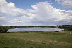
Druridge Bay is a 7-mile (11 km) long bay on the North Sea in Northumberland, England, stretching from Amble in the north to Cresswell in the south. Druridge Bay Country Park is situated on the bay, and part of the bay (the section near the farmstead of Druridge, in the centre of the bay) is owned by the National Trust. Coastal areas on the bay are set aside as nature reserves.
Nearby Places View Menu
1.8 km
Druridge Bay Country Park
Druridge Bay Country Park is adjacent to Druridge Bay between Amble and Cresswell, on the coastline of Northumberland, England. The country park was opened officially in 1989, but works had been ongoing since the 1970s to remediate the site after opencast coaling operations. The park is accessible by vehicle from the A1068 road, and is located on the England Coast Path. Public transport can be taken near to the park's closest village, which involves a 15-minute walk to get to the park.

2.1 km
Chibburn Preceptory
Chibburn Preceptory (also known as Low Chibburn Preceptory) are the ruins of a Medieval/Post-Medieval Hospitaller preceptory near Widdrington in Northumberland, England. The preceptory was first recorded in 1313, and it was abolished in 1540 when all its lands were passed to the Crown and later the Widdrington family. Low Chibburn had several uses, ranging from a hospital to a dowager house before being razed by French invaders in 1691. The preceptory buildings have undergone repair and restoration by Northumberland County Council, and the site is now a Scheduled Ancient Monument protected by law.

2.7 km
East Chevington
East Chevington is a parish in Northumberland, England, and was a village until it disappeared in the 1900s.
In 2001, the parish had a population of 3,192, increasing to 3,951 at the 2011 Census.
2.8 km
Hadston Skeers
Hadston Skeers (or Carrs) (Ordnance Survey reference NU 283428) are towards the northern End of Druridge Bay, Northumberland. They are made up of shelves of flat rocks, extending out into the North Sea for some distance, maybe half a mile, and are edged with weed-covered rocks.
This area is ideal for fish, particularly cod, and they are usually populated with numerous sea fishermen, even more so when conditions are right.
Fairly close by are Bondi Carrs (Ordnance Survey reference NU 286 018) form a large barrier at the northern end of Druridge Bay, near Low Hauxley, Amble.
The Green Skeers are further south and run for approximately 200 yard (60 m) along the beach at around the mid-tide mark.
The words skear (also spelt skeer, skere, and skerr) and carr, are Geordie dialect given to an area of low coastal rocks.