
 English
 Français

Ingram (Northumberland)
Ingram est une paroisse civile et un village du Northumberland, en Angleterre.
1. Notes et références
(en) Cet article est partiellement ou en totalité issu de l’article de Wikipédia en anglais intitulé « Ingram, Northumberland » (voir la liste des auteurs).
1. Liens externes
Portail de l’Angleterre
Nearby Places View Menu

2.4 km
Castle Knowe, Northumberland
Castle Knowe, also known as Clinch Castle, is the site of an Iron Age hillfort in Northumberland, England, about 1 mile south-east of the village of Ingram. It is a scheduled monument.

3.1 km
Branton, Northumberland
Branton is a village and former civil parish, now in the parish of Ingram, in Northumberland, England. It is about 9 miles (14 km) west of Alnwick. In 1951 the parish had a population of 50.

3.1 km
Brandon, Northumberland
Brandon is a village and former civil parish, now in the parish of Ingram, in Northumberland, in England. It is about 9 miles (14 km) north-west of Alnwick and 8 miles (13 km) south of Wooler in the Breamish Valley, just off the A697 north of Powburn. In 1951 the parish had a population of 58.
The village, or hamlet, is actually all one farm, farmed by the Shell family since at least the late 19th century. On the north side of the main road is a line of tied cottages and the old blacksmith's shop, still in good condition though lacking a blacksmith. On the south side is the traditional square of farm buildings and the Grade B listed farm house which now also provides 'bed and breakfast' accommodation. Hidden in the corner of a small paddock next to the road is the mill race, apparently just a line of very large flagstones but covering a deep and well preserved stone channel, which shows that the traditional square farm buildings once contained a mill. Some more modern buildings have been added on, mostly to the west end of the farm, however the older buildings are still in good original condition.
The farm has a mixed arable, livestock and contracting business. They were spared both the BSE and Foot & Mouth epidemics, in the first case by always having fed organic feeds free from animal protein.
4.1 km
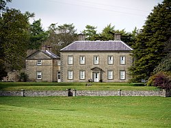
Roddam Hall
Roddam Hall is a privately owned 18th-century country house near Wooler, Northumberland. It is a Grade II listed building.
The Roddams, an ancient Northumbrian family, held lands at Roddam in ancient times. A survey of 1541 reported a decaying tower house without a barmkin owned by John Roddam. The Roddams lived at Houghton in Northumberland until the early 18th century, when Edward Roddam sold the Houghton estate and built a new three-storey five-bayed house at Roddam.
From 1776 the house was owned by Admiral Robert Roddam. He was a brother-in-law of General Sir Henry Clinton (1730–1795). On his death the estate passed to a distant cousin, William Spencer Stanhope, who changed his name to Roddam. He was High Sheriff of Northumberland in 1834. In 1848, the house was desecribed as "a handsome modern mansion, standing on a bold eminence which on the north forms the bank of a deep romantic dell watered by a tributary of the Till."
Roddam was remodelled in the early 1970s by the noted neo-classical architect Tom Bird (of Bird & Tyler Associates). Bird took off the top storey (a late, unattractive addition to the Georgian original) and dramatically reworked the interior.
In 2012 Roddam Hall was sold by Lord Vinson to Lord James Percy, younger brother of the Duke of Northumberland.

4.5 km
Hedgeley railway station
Hedgeley railway station served the area of Hedgeley, Northumberland, England from 1887 to 1953 on the Cornhill Branch.