
 English
 Français

Château de Buckton
Le château de Buckton est un bâtiment médiéval situé près de Stalybridge, en Angleterre.
Nearby Places View Menu
0 m
Buckton Castle
Buckton Castle was a medieval enclosure castle near Carrbrook in Stalybridge, a town in Tameside, Greater Manchester, England. Historically part of Cheshire, it was surrounded by a 2.8-metre-wide (9 ft) stone curtain wall and a ditch 10 metres (33 ft) wide and 6 metres (20 ft) deep. Buckton is one of the earliest stone castles in North West England and survives only as buried remains overgrown with heather and peat. It was most likely built and demolished in the 12th century. The earliest surviving record of the site dates from 1360, by which time it was already derelict. The few finds retrieved during archaeological investigations indicate that Buckton Castle may not have been completed.
In the 16th century, the site may have been used as a beacon during the Pilgrimage of Grace. In the 18th century, the castle attracted treasure hunters following rumours that gold and silver had been discovered at Buckton. The site was later used as an anti-aircraft decoy during the Second World War. Between 1996 and 2010, Buckton Castle was investigated by archaeologists as part of the Tameside Archaeology Survey, first by the University of Manchester Archaeological Unit and later by the University of Salford's Centre for Applied Archaeology. The project involved community archaeology, with more than 60 volunteers taking part. The castle, close to Buckton Vale Quarry, is a scheduled monument.

717 m
Heyheads
Heyheads is the easternmost area of Stalybridge, in Greater Manchester, England. The area includes the 16th century Grade II listed Nos 1, 2 and 3 Moorgate Farmhouse and adjoining barn and shippon buildings. Boundary cottages mark the boundary between Stalybridge and Mossley and the historic boundary between Cheshire and Lancashire. Modern Housing was built on Huddersfield Road in the 1970. With a further estate built close to Moorgate in the 1990s.
The view to the south is dominated by the steep-sided Buckton Hill, on the summit of which is located Buckton Castle.
Stamford Golf Club has an 18-hole course to the North of Huddersfield Road. The club was incorporated on Saturday 24 August 1901 and like the only pub in Heyheads, The Stamford Arms, was named after the local Landowner the Earl of Stamford.
1.1 km
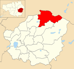
Mossley (ward)
Mossley is an electoral ward of Tameside, England. It is represented in Westminster by Jonathan Reynolds Labour Co-operative MP for Stalybridge and Hyde.
1.2 km
Mossley Hollins High School
Mossley Hollins High School is a coeducational secondary school located in Mossley, in the borough of Tameside, Greater Manchester. The school's original building was opened in the 1960s. Mossley Hollins ranked eighth in Tameside in the most recent league table of school GCSE performance. The school received a rating of "Good" in an Ofsted report made in 2023.
The Department for Education stated that the academic performance of students at Mossley Hollins was amongst the best in England with the GCSE results in English in 2014 placing them in the top 2% of schools nationally.
The school has a new £20 million building which opened to pupils on Wednesday, March 2, 2011.

1.3 km
Micklehurst railway station
Micklehurst Railway Station served the town of Mossley in Cheshire. It was built by the London and North Western Railway on its Micklehurst Line. The station closed for passengers in 1907 and to freight on 19 February 1962 but the line through the station remained open for passenger traffic until 7 September 1964. The station building on the up (Diggle to Stalybridge) side is still standing and is used as a private residence.