
 English
 Français

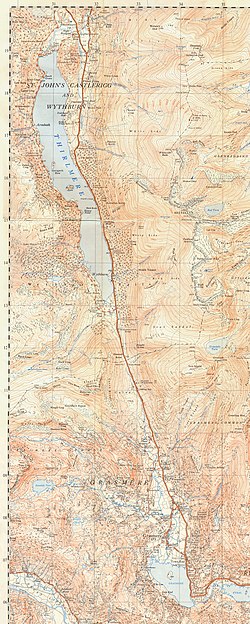
A591 road
The A591 is a major road in Cumbria, which lies almost entirely within the Lake District national park. A 2009 poll by satellite navigation firm Garmin named the stretch of the road between Windermere and Keswick as the most popular road in Britain. The 29.8 mile stretch between Kendal and Keswick was also named the UK's best driving road, according to a specially devised driving ratio formulated by car rental firm Avis.
Nearby Places View Menu
261 m
Dunmail Raise
Dunmail Raise is the name of a large cairn in the English Lake District, which may have been an old boundary marker. It has given its name to the mountain pass of Dunmail Raise, on which it stands. This mountain pass forms part of the only low-level route through the mountains between the northern and southern sides of the Lake District. According to local tradition, the cairn marked the burial of a king named Dunmail who was slain by Saxons. The place name itself may well be derived from the name of the historical Dyfnwal ab Owain, King of Strathclyde.

956 m
Steel Fell
Steel Fell is a fell in the English Lake District, lying between Thirlmere and Grasmere. It is triangular in plan, the ridges running north, west and south east. Steel Fell rises to the west of the Dunmail Raise road and can be climbed from the summit, or from Grasmere and Wythburn.

1.5 km
Seat Sandal
Seat Sandal is a fell in the English Lake District, situated four kilometres (2+1⁄2 miles) north of the village of Grasmere from where it is very well seen. Nevertheless, it tends to be overshadowed by its higher neighbours in the Eastern Fells, Helvellyn and Fairfield.
1.8 km
Gibson Knott
Gibson Knott is a fell in the English Lake District, an intermediate height on the ridge between Greenburn and Far Easedale in the Central Fells.