
 English
 Français
Gibson Knott
Gibson Knott is a fell in the English Lake District, an intermediate height on the ridge between Greenburn and Far Easedale in the Central Fells.
Nearby Places View Menu

941 m
Helm Crag
Helm Crag is a fell in the English Lake District situated in the Central Fells to the north of Grasmere. Despite its low height it sits prominently at the end of a ridge, easily seen from the village. This, combined with the distinctive summit rocks which provide the alternative name 'The Lion and the Lamb', makes it one of the most recognised hills in the District.
Alfred Wainwright wrote of Helm Crag that "The virtues of Helm Crag have not been lauded enough. It gives an exhilarating little climb, a brief essay in real mountaineering, and, in a region where all is beautiful, it makes a notable contribution to the natural charms and attractions of Grasmere."

1.3 km
Steel Fell
Steel Fell is a fell in the English Lake District, lying between Thirlmere and Grasmere. It is triangular in plan, the ridges running north, west and south east. Steel Fell rises to the west of the Dunmail Raise road and can be climbed from the summit, or from Grasmere and Wythburn.

1.6 km
River Rothay
The Rothay is a spate river of the Lake District in north-west England. Its name comes from Old Norse and translates literally as the red one. This has come to mean trout river. It rises close to Rough Crag above Dunmail Raise at a point about 1542 feet (470 m) above sea level (grid reference NY306108). Its catchment area covers Grasmere Common including Easedale Tarn, the southern flanks of Fairfield, and several of the fells to the east of Dunmail Raise, including Great Rigg, Rydal Fell, Scandale Fell and Heron Pike.
From its source the Rothay descends through the valley of Greenburn Bottom to the hamlet of Helmside not far from the main A591 road over Dunmail Raise. Just north of the village of Grasmere the river subsumes Easedale Gill and Sour Milk Gill, the latter flowing out of Easedale Tarn. In the village the river flows close to the churchyard where the poet Wordsworth is buried. The Rothay then flows into the head of the lake of Grasmere (elevation 208 feet/63 m). As well as replenishing Grasmere, the Rothay also drains it, flowing for just half a mile (800 m) from the southern end of the lake before replenishing Rydal Water (elevation 181 feet/55 m) at its western extremity. The Rothay drains Rydal from its easternmost point and then flows in a general southerly direction for about three miles (4.8 km) before merging with the River Brathay at Croft Lodge south-west of Ambleside. From there the rivers flow into the northern end of Windermere. In addition to those tributaries already noted, several others are subsumed by the Rothay.
About a mile (1.6 km) north of Ambleside the Rothay is crossed by a well-known set of stepping stones. Several sections of the Rothay are popular with canoeists, including the section between Grasmere and Rydal; the river is graded as 2+. The Rothay is a trout fishery where brown trout can be caught. Anglers should enquire locally about licences (an Environment Agency Rod Licence is required).
The River Rothay is wholly within the historic county of Westmorland. After local government reorganisation in 1974 the river was in the administrative county of Cumbria. Following further local government reorganisation in 2023 the river flows within the council area administered by Westmorland and Furness Council.
1.6 km
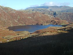
Easedale Tarn
Easedale Tarn is a tarn in the centre of the English Lake District, about two miles west of the village of Grasmere. It lies in a hollow between Tarn Crag to the north and Blea Rigg to the south, about 910 feet or 280 metres above sea level. The hollow was formed by a small corrie glacier, and is believed to have filled with water around 11,000 years ago when the ice finished melting.
Easedale Tarn is one of the larger tarns in the district, about 480 metres (1,570 ft) long and 300 metres (980 ft) wide. Its outflow is Sourmilk Gill, named after the milky white colour of its waterfalls, which runs east towards Grasmere. The gill displays impressive water scenery when seen from Grasmere, and from the path to the tarn.
The tarn is a popular destination for walkers. Many people climb the path from Grasmere which overlooks Sourmilk Gill. The ascent was popular during the Victorian period, and a refreshment hut was even established in the 19th century by Robert Hayton of Grasmere above the outlet of the tarn to service the thirsty visitors. The hut is long gone, and nettles now grow where the ruins used to be.