


Kettlewell with Starbotton is a civil parish in the county of North Yorkshire, England. Kettlewell is a village in Upper Wharfedale, North Yorkshire, England. It lies between the villages of Grassington, Kilnsey and Conistone to the south, Starbotton to the northwest, the hamlet of Horsehouse to the northeast, and later on Coverdale.


Localisation
2 explorateurs ont visité ce lieu
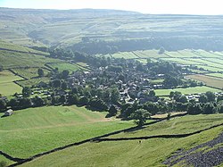


Kettlewell nestles at the feet of Great Whernside, and Buckden Pike, where Park Gill Beck joins the River Wharfe, and set to the east of the Wharfe. Both river and beck are joined by attractive stone bridges there. Starbotton is a hamlet of around 70 houses situated in the Yorkshire Dales National Park, by the River Wharfe in Wharfedale. The resident population is only around 75 with many of the village houses being used as holiday accommodation. There are only two remaining working farms - one at either end of the village, the rest having been converted in one way or another. It is on the opposite bank of the River Wharfe to the Dales Way halfway between Kettlewell and Buckden. Until 1974 it was part of the West Riding of Yorkshire. From 1974 to 2023 it was part of the district of Craven, it is now administered by the unitary North Yorkshire Council.
See also
Listed buildings in Kettlewell with Starbotton