


The Dün (German pronunciation: [dyːn]) is a hill chain in northwestern Thuringia, Germany. It runs west to east, and forms the northwestern edge of the Thuringian Basin. It separates the Thuringian Basin from the upper valley of the river Leine. Towards the east it continues in the Hainleite ridge. The highest point, 522 m above sea level, is near the village Vollenborn.
Localisation
1 explorateur a visité ce lieu


6.1 km
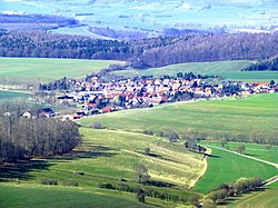
Niederorschel est une commune allemande située dans l'arrondissement d'Eichsfeld en Thuringe.

6.7 km
La Communauté d'administration d'Eichsfelder Kessel réunit six communes de l'arrondissement d'Eichsfeld en Thuringe. Elle a son siège dans la commune de Niederorschel et a été créée le 4 février 1991.
La communauté regroupe 5 707 habitants en 2010 pour une superficie de 55,24 km2.
Communes :
Deuna ;
Gerterode ;
Hausen ;
Kleinbartloff ;
Niederorschel ;
Vollenborn.
