
 English
 Français

Upperton, North Lanarkshire
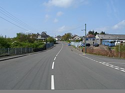
Upperton is a village in North Lanarkshire, Scotland, near Airdrie and Cumbernauld, about 20 miles (32 km) north-east of Glasgow. It lies close to the B803 between Greengairs and Slamannan. Other nearby roads include Hulks Road towards the A73, Fannyside Road to Abronhill and the road to Caldercruix via Longriggend. The Avon Water flows through the village and meets the Shielhill Burn, a tributary of the River Avon, just outside the village. William Forrest's 1816 map of Lanarkshire shows the site as Upper Town. The Ordnance Survey map sites "Uppertown" on Shiel Hill.
Lieux à Proximité Voir Menu
1.9 km

2.0 km

3.1 km

3.8 km

4.6 km