
 English
 Français

Upperton, North Lanarkshire
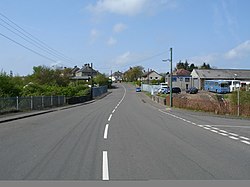
Upperton is a village in North Lanarkshire, Scotland, near Airdrie and Cumbernauld, about 20 miles (32 km) north-east of Glasgow. It lies close to the B803 between Greengairs and Slamannan. Other nearby roads include Hulks Road towards the A73, Fannyside Road to Abronhill and the road to Caldercruix via Longriggend. The Avon Water flows through the village and meets the Shielhill Burn, a tributary of the River Avon, just outside the village. William Forrest's 1816 map of Lanarkshire shows the site as Upper Town. The Ordnance Survey map sites "Uppertown" on Shiel Hill.
Nearby Places View Menu
1.8 km
Longriggend railway station
Longriggend railway station was a railway station serving the village of Longriggend, North Lanarkshire, Scotland. The station was part of the Slamannan Railway which amalgamated with several other local railways to form the Monkland Railways.
1.9 km
Greengairs
Greengairs is a village in North Lanarkshire, Scotland.
Greengairs is shown on a map by Roy c.1754 under the name of Green Geirs. In toponymy, the name means "green strips of grass".
Lying 3 miles (5 km) southeast of Cumbernauld and 3 miles (5 km) north east of Airdrie, the village consists mainly of local authority housing. Between them Greengairs and Wattston have about 1,190 residents.
It developed in the nineteenth century due to increased coal mining and quarrying. Ironstone was first mined by the Summerlee Iron Company in the 1840s. It was in the parish of New Monkland or East Monkland. It also historically had its own school; the teachers had a house but no salary. The village was badly affected by the Stanrigg Mining Disaster where, in July 1918, a collapse led to the deaths of 19 miners, 6 of whom came from Greengairs.
Greengairs power station opened in 1996, and is powered by methane produced by biodegrading materials from a large landfill site developed since 1990 in former open cast workings situated to the south of the village. Greengairs is the largest landfill site in Scotland, handling waste from Glasgow and Edinburgh. Greengairs has 6000m of pipes with biogas fed by 90 gas wells.

2.0 km
Longriggend
Longriggend is a village in North Lanarkshire, Scotland, with a population of approximately 200.

2.0 km
Greengairs Landfill
The Greengairs Landfill is a landfill site in Scotland that receives non-hazardous household, commercial and industrial waste from the North Lanarkshire area. Greengairs was opened in 1990 and features landfill gas collection systems which are used to generate electricity for export into the National Grid.
The landfill is owned and operated by FCC Environment.