
 English
 Français

Bridge of Orchy
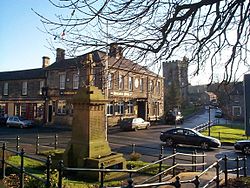
Bridge of Orchy (Scottish Gaelic: Drochaid Urchaidh) is a village in Glen Orchy in Argyll and Bute, Scotland. It is named after the crossing over the River Orchy, which was constructed by British Army during the pacification of the Highland Clans following the Battle of Culloden in 1746. Military roads were built between the Scottish Lowlands and Highlands of northern Scotland to facilitate the speedy movement of Crown forces.
The village, which is dated to 1751, is on the A82 road. The nearby Bridge of Orchy railway station opened on the West Highland Line in 1894.
The 96 mi (154 km) West Highland Way long-distance trail runs through the village. Nearby prominent peaks include the munros Beinn Dorain and Beinn an Dòthaidh. The River Orchy is one of the finest white-water rivers in the United Kingdom.

Battle of Mouscron
The Battle of Mouscron (28–29 April 1794) was a series of clashes that occurred when the Republican French Army of the North under Jean-Charles Pichegru moved northeast to attack Menin (now Menen) and was opposed by Coalition forces under the overall leadership of François Sébastien Charles Joseph de Croix, Count of Clerfayt. In their initial advance, the French began the siege of Menin and captured Courtrai (now Kortrijk). With Habsburg Austrian reinforcements, Clerfayt counterattacked on the 28th but Joseph Souham soon massed superior French forces and drove the Coalition troops out of the area. This Flanders Campaign action happened during the War of the First Coalition, part of the French Revolutionary Wars. The battle occurred near Mouscron, Belgium, located at the French border 9 kilometres (6 mi) south of Kortrijk and at Menen, located 11 kilometres (7 mi) west of Kortrijk.
Because most of the Coalition army was covering the Siege of Landrecies, the early French advance was largely successful in driving back a weak screen of Hanoverian troops. On the north bank of the Lys River, a division under Jean Victor Marie Moreau besieged Menen, while Souham's division operated on the south bank. Clerfayt's foray enjoyed initial success at Mouscron, but Souham on his own initiative concentrated superior forces against the Coalition. Completely isolated by Clerfayt's defeat, the largely Hanoverian garrison of Menin under Rudolf von Hammerstein broke out of the fortress and escaped on the 30th. The next action occurred at the Battle of Courtrai on 10 May.

Oxenhope
Oxenhope is a village and civil parish near Keighley in the metropolitan borough of Bradford, West Yorkshire, England. It is historically part of the West Riding of Yorkshire. The population was 2,476 at the time of the 2001 census and had increased to 2,626 at the 2011 Census. Oxenhope railway station is the terminus for the Keighley and Worth Valley Railway heritage railway.

Valley Bridge
Valley Bridge is a road bridge in Scarborough, North Yorkshire, England. It spans Ramsdale and was built in 1865.
It was first built as Lendal Bridge, York, but it collapsed there and was later brought to Scarborough.

Leeds Inner Ring Road
The Leeds Inner Ring Road is part-motorway and part-A roads in Leeds, West Yorkshire, England, which forms a ring road around the city centre.
It has six different road numbers that are all sections of longer roads. Clockwise, the roads are the A58(M), a motorway section of the A58 road; the A64(M), part of the A64 road; the A61 between York Road and the M621; the M621 between junctions 4 and 2; and the A643 between the M621 and A58. The motorway section is in total is 2.5 miles (4.0 km) long and is subject to a 40 mph (64 km/h) speed limit throughout.

Low Moor Ironworks
The Low Moor Ironworks was a wrought iron foundry established in 1791 in the village of Low Moor about 3 miles (4.8 km) south of Bradford in Yorkshire, England. The works were built to exploit the high-quality iron ore and low-sulphur coal found in the area. Low Moor made wrought iron products from 1801 until 1957 for export around the world. At one time it was the largest ironworks in Yorkshire, a major complex of mines, piles of coal and ore, kilns, blast furnaces, forges and slag heaps connected by railway lines. The surrounding countryside was littered with waste, and smoke from the furnaces and machinery blackened the sky. Today Low Moor is still industrial, but the pollution has been mostly eliminated.

Gowrie
Gowrie (Scottish Gaelic: Gobharaidh) is a region in central Scotland and one of the original provinces of the Kingdom of Alba. It covered the eastern part of what became Perthshire. It was located to the immediate east of Atholl, and originally included the area around Perth (and the ancient Scottish royal sites of Scone), though that was later detached as Perthia.
Its chief settlement is the city of Perth. Today it is most often associated with the Carse of Gowrie, the part of Gowrie south of the Sidlaw Hills running east of Perth to Dundee.

Wadsworth, West Yorkshire
Wadsworth is a civil parish in the Metropolitan Borough of Calderdale in West Yorkshire, England. It has a population of 1,456, increasing to 1,603 at the 2011 Census, and was, until 1974, part of Hepton Rural District.
Historically part of the West Riding of Yorkshire, the main settlements in the parish are Old Town, Chiserley and Pecket Well. It was named a berewick of Wakefield in the Domesday Book of 1086, and thus subsequently recorded as a subinfeudatory manor, before its subsequent extinguishment in the nineteenth century. From the seventeenth century it was also one of five townships forming the chapelry of Heptonstall.

Auchenreoch
Auchenreoch, or Auchinreoch is a small hamlet formerly in Stirlingshire but now in East Dunbartonshire, Scotland near Kilsyth and Kirkintilloch.
A sparsely populated farming community, within the hamlet is Auchinreoch Stables. The stable was the home of famous Grand National winner Red Rum from the horse's retirement from racing in 1978 until his death in 1995.

Wavertree Windmill
Wavertree Mill was a fifteenth-century windmill which stood in Wavertree, Liverpool, England. As a post mill, the wooden superstructure could be rotated on its base to catch the wind, by means of a projecting pole attached to a cartwheel.
First recorded in 1452, the mill was the property of the crown until 1639, when Charles I granted it to James Stanley, then known as Lord Strange. By 1676, the mill was in the possession of James Stanley's grandson, William. The new owners retained the right of soke, meaning that their tenants were forbidden to have their corn ground at any other mill. In 1768, the ownership of the mill passed to Bamber Gascoyne of Childwall Hall. It was subsequently owned by the Marquess of Salisbury, and was finally leased by Colonel James Bourne.
One of the mill's sails was torn off during a gale in 1895, and subsequent damage had left it a wreck by the following year. The mill was demolished in 1916, despite local opposition.
In 1986, preparatory to the building of two new houses on the site, an archaeological dig was carried out, which unearthed the brick and stone foundations of the mill. These remains were dated to the eighteenth century, and are still visible in the front garden of one of the new houses, having been transplanted 15 yards (14 m) from their original location.

St Joseph's Roman Catholic High School, Horwich
St Joseph's Roman Catholic High School and Sports College is a voluntary aided comprehensive school located in Horwich, Greater Manchester, England. It is under trusteeship of the Roman Catholic Diocese of Salford and is maintained by Bolton Metropolitan Borough Council.
The school is in the top 4 schools (three of which are faith schools) at GCSE in the Metropolitan Borough of Bolton. On 2 June 2020, the school was formally admitted as a member to the worldwide UNESCO Associated Schools Network.
The school offers GCSEs as programmes of study for pupils.

York
York is a cathedral city in North Yorkshire, England, with Roman origins, sited at the confluence of the rivers Ouse and Foss. It has many historic buildings and other structures, such as a minster, castle and city walls, all of which are Grade I listed. It is the traditional county town of Yorkshire, and the administrative centre of the City of York district. It is located 27 miles (43 km) north-east of Leeds, 90 miles (140 km) south of Newcastle upon Tyne and 207 miles (333 km) north of London. York's built-up area had a recorded population of 141,685 at the 2021 census.
The city was founded under the name of Eboracum in AD 71. It then became the capital of Britannia Inferior, a province of the Roman Empire, and was later the capital of the kingdoms of Deira, Northumbria and Scandinavian York. In the Middle Ages it became the northern England ecclesiastical province's centre, and grew as a wool-trading centre. In the 19th century it became a major railway network hub and confectionery-manufacturing centre. In the Second World War York was bombed in the Baedeker Blitz. Although York was less targeted during the war than other, more industrialised northern cities, several historic buildings were gutted and restoration took place up until the 1960s.
Historic local governance of the city was as a county corporate, not included in the county's riding system. The city has since been locally governed as a municipal borough, county borough, and since 1996, a non-metropolitan district (the City of York), which also includes surrounding villages and rural areas, and the town of Haxby. The current district's local council, City of York Council, is responsible for providing all local services and facilities throughout this area.

Sir Gabriel Wood's Mariners' Asylum
Sir Gabriel Wood's Mariners' Asylum is a facility in Greenock, Scotland which opened 17 October. 1854. It was built to house and care for aged and impoverished seamen belonging to the counties of Renfrewshire (historic), Ayrshire, Dunbartonshire, Argyll, and County of Bute. Its founder, Sir Gabriel Wood (1767–1845), served as Vice-Consul for the state of Maryland and later as Commissary-General of Accounts for the Caribbean, then of the Mediterranean, and finally of Canada. He bequeathed his entire estate to his wife Louisa Augusta and his sister Francis Ann Wood. A memorandum instructed them to establish a home providing for the care of local destitute seamen. Sir Gabriel Wood's Mariners' Asylum was included in the 1861 United Kingdom census. At that time, there were forty-five former mariners and seamen residing there with ages ranging from 58 to 84 years old. The staff included the Governor of the Institution, Adam MacKay, a matron, a housekeeper, a laundress, and two servants. In November 2020, inspections by Care Inspectorate (Scotland) identified several deficiencies in the care being provided. The Trustees of the Sailors' Society who owned the facility decided to close the home. As reasons, they cited increased pressures resulting from the COVID-19 pandemic, and lack of resources to uphold the standards they set for the home. In March 2022, the property was sold to Torah Capital Limited, a London company.

Roseworth
Roseworth is an area in the Borough of Stockton-on-Tees, County Durham, England.
It borders Hardwick to the south west, Ragworth to the south east (in the same ward) and Norton centre to the east.
The Roseworth housing estate was built in the 1960s, and every street name on the estate begins with "R".
Rothbury
Rothbury is a market town and civil parish in Northumberland, England, on the River Coquet. It is 14 miles (22.5 km) north-west of Morpeth and 26 miles (42 km) north of Newcastle upon Tyne. At the 2011 census, it had a population of 2,107.
Rothbury emerged as an important town because of its location at a crossroads over a ford on the River Coquet. Turnpike roads leading to Newcastle, Alnwick, Hexham and Morpeth allowed for an influx of families and the enlargement of the settlement during the Middle Ages. In 1291, Rothbury was chartered as a market town and became a centre for dealing in cattle and wool for the surrounding villages during the Early Modern Era. Later, Rothbury developed extensively in the Victorian era, due in large part to the railway and the industrialist Sir William Armstrong. Between 1862 and 1865, Armstrong built Cragside, a country house and "shooting box" (hunting lodge) just outside Rothbury, and extended it as a "fairy palace" between 1869 and 1900. The house and its estate are now owned by the National Trust and are open to the public, attracting many visitors to the area.

St James' Church, Barrow-in-Furness
St. James Church located on Blake Street in Barrow-in-Furness, belongs to the Church of England's Diocese of Carlisle within the ecclesiastical Province of York. The present church building dates from the mid-19th century and is Grade II* listed.

White Rose railway station
White Rose is a planned railway station between Cottingley and Morley railway stations on the Huddersfield Line. It was featured in the Government's plans for the railway in November 2017 and in July 2018 further details were revealed as part of the Connecting Leeds Vision with the consultation inviting opinions from the general public. It is anticipated by the developers that Cottingley railway station will close due to the proximity of the two stations.

Fountains Hall
Fountains Hall is a country house near Ripon in North Yorkshire, England, located within the World Heritage Site at Studley Royal Park which include the ruins of Fountains Abbey. It belongs to the National Trust and is a Grade I listed building.

St Austin's Church, Wakefield
St Austin's Church is a Roman Catholic Church building in Wakefield, England. It is situated near where Northgate meets Marsh Way close to the city centre. It was founded in 1827 by the Society of Jesus and is a Grade II listed building.

Lauriston Castle
Lauriston Castle is a 16th-century tower house with 19th-century extensions overlooking the Firth of Forth, in Edinburgh, Scotland. It lies on Cramond Road South, between Cramond, Davidson's Mains, and Silverknowes. The substantial grounds, Lauriston Castle Gardens, operate as a local park. The castle was bequeathed to the Edinburgh Corporation (post 1975 known as Edinburgh City Council) and hosts the Lord Provost's annual Garden Party. The house is a Category A listed building and the grounds are included in the Inventory of Gardens and Designed Landscapes in Scotland.