
 English
 Français

Deanston
Deanston (Scottish Gaelic: Baile an Deadhain) is a village in the Stirling council area, Scotland, on the south bank of the River Teith east of Doune, in south-west Perthshire. It is a part of the parish of Kilmadock.
Nearby Places View Menu

169 m
Deanston distillery
Deanston distillery is a Single Malt Scotch whisky distillery and it is the largest distillery owned by Scotch whisky producer CVH Spirits Limited, who also own Bunnahabhain Distillery on the Isle of Islay and Tobermory distillery on the Isle of Mull. located on the banks of the River Teith, eight miles from the historic town of Stirling, at the gateway to the dramatic Loch Lomond & Trossachs National Park.
Deanston Distillery started life in 1785 as a cotton mill designed by Sir Richard Arkwright, and remained as such for 180 years until it was transformed into a distillery in 1966. The constant supply of pure water from the River Teith contributed to the decision to turn the mill into a distillery and Deanston is now the only distillery in Scotland to be self-sufficient in electricity, with power generated by an on-site hydro-energy facility. Deanston sits in the Highland single malt region of Scotland and produces whisky which is handmade by ten local craftsmen, un-chill filtered, natural colour and bottled at a strength of 46.3% ABV.

1.1 km
Doune railway station
Doune was a railway station located in Doune, in the council area of Stirling, Scotland.
The station was rebuilt in typical Caledonian Railway style in the early 1900s after the completion of the Callander and Oban Railway in 1880. It closed on 1 November 1965 and was demolished around 1968. The site was used by a timber merchant for many years. In the late 1990s a private housing estate was built on the station site. Although little or no trace of the station remains, the station house still stands at the entrance to the housing development.
1.1 km
Kilmadock
Kilmadock parish (Scottish Gaelic Cille Mo Dog), named for Saint Cadoc, containing the settlements of Doune, Deanston, Buchany, Argaty, Hill of Row, Drumvaich, and Delvorich, is situated in Stirling council area, Scotland, and is on the southern border of the former county of Perthshire. Its length is 10 miles (16 kilometres), its breadth from 2–8 mi (3–13 km), and with an area of 24,521 acres (9,923 hectares).
The River Forth runs along its southern boundary, and the River Teith runs east-south-eastward through the centre. A flat tract of considerable breadth lies along the Forth Valley, flanked on each side by a hill-ridge. The valley is traversed by the Teith, and an upland tract, part of the Braes of Doune, ascends to the summit of Uamh Mhòr on the northern boundary.

1.3 km
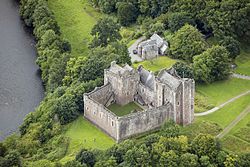
Doune
Doune (; from Scottish Gaelic: An Dùn, meaning 'the fort') is a burgh within Perthshire. The town is administered by Stirling Council. Doune is assigned Falkirk postcodes starting "FK". The village lies within the parish of Kilmadock and mainly within the area surrounded by the River Teith and Ardoch Burn.
In the 2001 Scottish census, 2.75% residents of Doune could speak Scottish Gaelic.
Doune has a small primary school with 183 pupils on the roll (June 2016), drawn from a catchment area which extends outside the town, especially to the north. It is located on the site of Doune Roman fort. Gaelic is taught in Primary 1–7 and Spanish is now taught from P5 upwards .