
 English
 Français
Great Limber Priory, Limber Magna
Great Limber Priory, Limber Magna was a priory in Great Limber (or Limber Magna), Lincolnshire, England. The manor and church of Great Limber were granted by Richard de Humet, constable of Normandy, France, and Agnes his wife, to the Cistercian abbey of Aunay in Normandy, and their charter was confirmed by King Henry II in 1157. It is uncertain whether it was a priory or a grange. The manor and church were sold by the abbot of Aunay in 1393 to the priory of St. Anne at Coventry. see also
Great Limber Preceptory, Limber Magna
Nearby Places View Menu
0 m
Great Limber Preceptory, Limber Magna
Great Limber Preceptory, Limber Magna was a Camera (farm) of the Knights Templar and later the Knights Hospitaller in the village of Great Limber (or Limber Magna), Lincolnshire, England.
The manor and church of Great Limber were granted by Richard de Humet of Normandy, France and Agnes his wife, to the Cistercian abbey of Aunay in Normandy, and their charter was confirmed by King Henry II in 1157. It seems likely that the property was a grange rather than a priory. The manor and church were sold by the abbot of Aunay in 1393 to the priory of St. Anne at Coventry.
The site of the grange, or priory, later became a Camera (farm) of first the Knights Templars, and then the Knights Hospitallers between the 14th and 16th centuries. After the Dissolution of the Monasteries in 1540 the house was first occupied by Thomas Smyth and then sold to the
Pelham family until its abandonment in the 17th century. The site is now an ancient scheduled monument.

511 m
Great Limber
Great Limber is a village and civil parish in the West Lindsey district of Lincolnshire, England. The population of the civil parish at the 2011 census was 271. It is on the A18, 8 miles (13 km) west from Grimsby and 8 miles east from Brigg.
In 1885 Kelly's Directory noted a Wesleyan chapel, built in 1841. The parish of 4,970 acres (20 km2), including 936 acres (3.8 km2) of woodland, was farmed on four and five field systems, and produced chiefly wheat, barley and turnips. Its population in 1881 was 489.
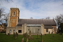
Great Limber Grade I listed Anglican church is dedicated to St Peter. It is built in Norman and Decorated styles, consisting of chancel, nave, and aisles, with attached chapels and south porch, and a low crenellated west tower with three bells. The church was partly restored in 1873. Its chancel is mostly Victorian, although its arch is 13th-century as is the font. An 1890 stained glass window in the north aisle is by Kempe.
2.6 km
Keelby
Keelby is a village and civil parish in the West Lindsey district of Lincolnshire, England, on the A18, 6 miles (10 km) west from the seaport of Grimsby and 4 miles (6 km) east from the local Humberside Airport, with close access to the A180 to the north, and M180 to the west.
In the 2001 Census it had a population of 2,172, comprising 48.6% males, and 51.4% females. The population at the 2021 census (including Brocklesby) was 2,226, comprising 47.4% males, and 52.6% females.
Keelby is listed in the Domesday Book as "Chelebi" or "Chilebi". A place name ending in "-by" generally indicates that the town or village was a primary Viking settlement.
Keelby has a tennis court, bowling green, park, primary school, guest house and a war memorial, a Mace and a Spar store, and two public houses, the King's Head and the Nag's Head. Religious sites are the Church of England St Bartholomew's Church and a Methodist chapel.
Keelby once had a village pond situated at the junction of Pelham Crescent and Mill Lane, however this was filled in during the 1950s.
There is a football club with adult and junior teams. The village cricket club, reformed in 1975 after a 10-year break, plays in the Lincolnshire League, the Grimsby Midweek League and the East Lindsey Sunday League. Matches were played on the village green until 2009 before moving to a new multi-purpose sports complex on the edge of the village in 2010.
Keelby is within the catchment area of three secondary schools, Healing Comprehensive, Caistor Yarborough, and Caistor Grammar School.
The village was struck by an F1/T2 tornado on 23 November 1981, as part of the record-breaking nationwide tornado outbreak on that day.
Keelby has been twinned with Maisdon-sur-Sèvre, a village in western France, since 1990. There is a street in the French village named after Keelby, Allée de Keelby.

2.8 km
Brocklesby
Brocklesby is a village and civil parish in the West Lindsey district of Lincolnshire, England. It is situated 1 mile (1.6 km) south of Habrough, 4 miles (6.4 km) south-west of Immingham, it is located close to the border of both North Lincolnshire and North East Lincolnshire and is near Humberside International Airport. Its location makes it the most northerly village within the East Midlands region.
According to the 2001 Census, Brocklesby had a population of 124. At the 2011 census, the population was listed in the civil parish of Keelby.
The parish includes the settlement of Limber Parva (or Little Limber), which lies 1.5 miles (2.4 km) to the south-west, and is the site of a deserted medieval village, defined by earthworks and crop marks of crofts, hollow ways and rectilinear enclosures.
Newsham Abbey was located to the north of the village in the hamlet of Newsham, now part of the Brocklesby civil parish.
Brocklesby had a railway station until the 1990s, and it was closed. The station building and platforms are now a private residence, with the main railway lines still passing through it. The nearest railway station in current use is at Habrough.