
 English
 Français
Pike Hill Signal Tower
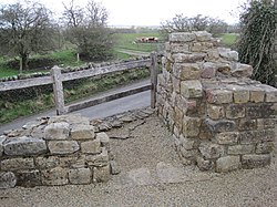
Pike Hill Signal Tower was one of a number of signal stations that were built on high ground overlooking the line of the Roman Stanegate road in northern Britannia during the early 2nd century. It later became incorporated into Hadrian's Wall. Its remains, a 2-metre (6 ft 7 in) long fragment of the south-east wall, lie south of a modern road cutting and field wall, located in the parish of Waterhead in Cumberland, United Kingdom. The tower is located between Turret 51B and Turret 52A with the fort of Banna located to the east.
Nearby Places View Menu

300 m
Milecastle 52
Milecastle 52 (Bankshead) was a milecastle on Hadrian's Wall (grid reference NY57946490).

678 m
Banks, Cumbria
Banks is a village in Cumbria, England, astride the course of Hadrian's Wall, 3 mile (5 km) NE of the market town of Brampton. The historic Lanercost Priory is just a mile (1.5 km) to the SW.
Banks East Turret is a relatively well-preserved turret with adjoining stretches of Hadrian's Wall.

784 m
Leahill Turret, Hadrian's Wall
Leahill Turret is a typical example of one of the lookout towers located between the milecastles on Hadrian's Wall in Cumbria, located on the Lanercost Road near Banks, Parish of Waterhead. It is designated turret 51b and lies east of the Signal Tower at Pike Hill.

1.2 km
Milecastle 53
Milecastle 53 (Banks Burn) was a milecastle on Hadrian's Wall (grid reference NY56486460).