
 English
 Français
West Linton
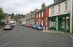
West Linton (en gaélique écossais : Liontan Ruairidh) est un village situé dans la lieutenance de Tweeddale, en Écosse, à 26 km au sud-ouest d'Édimbourg. Le festival The Whipman a lieu dans le village depuis 1803. Il commence la veille du premier samedi de juin et dure huit jours, période pendant laquelle se tiennent de nombreuses festivités et activités sportives.
Lieux à Proximité Voir Menu

0 m
West Linton
West Linton (Scottish Gaelic: Baile Linne Ruairidh) is a village and civil parish in southern Scotland, on the A702. It is in the county of Peeblesshire (also known as Tweeddale) and the Scottish Borders council area. Many of its residents are commuters, owing to the village's proximity to Edinburgh, which is 16 miles (26 km) to the north-east. West Linton has a long history, and holds an annual traditional festival called The Whipman Play.

976 m
Broomlee railway station
Broomlee railway station served the village of West Linton, Peeblesshire, Scotland, from 1864 to 1933 on the Leadburn, Linton and Dolphinton Railway.
3.5 km
Macbie Hill railway station
Macbie Hill railway station served the hamlet of Coalyburn, Peeblesshire, Scotland, from 1864 to 1933 on the Leadburn, Linton and Dolphinton Railway.

3.9 km
Romannobridge
Romannobridge is a hamlet on the Lyne Water, on the A701, in the Scottish Borders.
Settlements nearby include West Linton, Halmyre, Dolphinton, Blyth Bridge, and Mountain Cross. The village is served by a community centre (the Newlands Centre), a small primary school (Newlands Primary) and a church (Kirkurd and Newlands Parish Church of Scotland).
The three-span bridge itself was constructed in 1774.
Romannobridge is on the route of the main drovers' road for livestock headed to market in England, and is now a stop on the Cross Borders Drove Road long-distance path.

4.3 km
Carlops
Carlops (Scottish Gaelic: Leum na Caillich) is a small village in the Pentland Hills, within the Scottish Borders area of Scotland, close to the boundary with Midlothian. It lies between West Linton and Penicuik.
The village was founded in 1784 and developed cotton weaving, coalmining and limestone mining.
The name derives from the Scots "Carlins Lowp" (English: "Witches' Leap"), since near the south of the village there are two exposed rock faces about 20 m (66 ft) high facing each other, with a similar distance between them. Folklore maintained that witches would leap from one face to the other, over the chasm, for entertainment of an evening.