
 English
 Français

Carlops
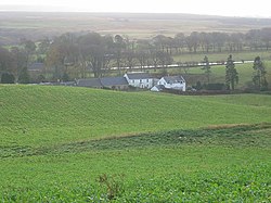
Carlops (Scottish Gaelic: Leum na Caillich) is a small village in the Pentland Hills, within the Scottish Borders area of Scotland, close to the boundary with Midlothian. It lies between West Linton and Penicuik. The village was founded in 1784 and developed cotton weaving, coalmining and limestone mining. The name derives from the Scots "Carlins Lowp" (English: "Witches' Leap"), since near the south of the village there are two exposed rock faces about 20 m (66 ft) high facing each other, with a similar distance between them. Folklore maintained that witches would leap from one face to the other, over the chasm, for entertainment of an evening.
Nearby Places View Menu
2.4 km
Nine Mile Burn
Nine Mile Burn is a hamlet in Midlothian, Scotland, the last in Midlothian when heading south on the A702 road.
It is located at the foot of the Pentland Hills, near Penicuik and about 2 km north-east of the village of Carlops.
3.0 km
Pentland Hills
The Pentland Hills are a range of hills southwest of Edinburgh, Scotland. The range is around 20 miles (30 kilometres) in length, covers an area of 35 square miles (91 km2), and runs southwest from Edinburgh towards Biggar and the upper Clydesdale. The hills have been designated as a Scottish regional park.
4.1 km
Macbie Hill railway station
Macbie Hill railway station served the hamlet of Coalyburn, Peeblesshire, Scotland, from 1864 to 1933 on the Leadburn, Linton and Dolphinton Railway.

4.3 km
West Linton
West Linton (Scottish Gaelic: Baile Linne Ruairidh) is a village and civil parish in southern Scotland, on the A702. It is in the county of Peeblesshire (also known as Tweeddale) and the Scottish Borders council area. Many of its residents are commuters, owing to the village's proximity to Edinburgh, which is 16 miles (26 km) to the north-east. West Linton has a long history, and holds an annual traditional festival called The Whipman Play.