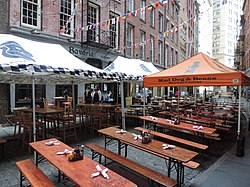
Coenties Slip is a street in the Financial District of Manhattan in New York City. It runs southeast for two blocks in Lower Manhattan from Pearl Street to South Street. A walkway runs an additional block north from Pearl Street to Stone Street. The slip was originally an artificial inlet in the East River for the loading and unloading of ships that was land-filled in 1835. The entire length of the road is a pedestrian street, though before 2013, the block north of Water Street carried vehicular traffic.

1. Pronunciation

In 2003, Gerard Wolfe reported the pronunciation of Coenties to be KOH-ən-teez and in 2023 Jackson Arn reported it as (“co-en-tees”). Earlier reports include KWIN-seez (1896), KWEN-chiz (1917), and KWIN-cheez (1908).

1. History

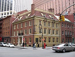
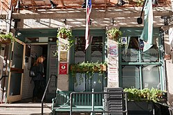
Although surrounded by skyscrapers, a row of buildings from the 19th century still stands along the block that is open to vehicles. These buildings are in active use by small businesses. The blocks between Water Street and Front Street, and between Front Street and South Street, were removed to make way for these high rise buildings. Part of 55 Water Street and part of the Vietnam Veterans Plaza are built on land that was once part of Coenties Slip. Both Coenties Slip and Coenties Alley are named after Conraet Ten Eyck and his wife Antje. Arthur Bartlett Maurice describes Coenties Slip in the 1935 book Magical City: “At the head of the Slip, where the Elevated road winds its way along Pearl Street on its way from South Ferry to Hanover Square, stood the Stadt Huys of Dutch days, the first City Hall on Manhattan Island. After the Erie Canal was finished in 1825, the slip, then only a tiny corner of what it is today, harbored many of the canal boats." The land was infilled by 1835 and new buildings were developed, only to be destroyed shortly afterward in the Great Fire of New York.

In 2010, the Downtown Alliance proposed upgrades to Coenties Slip and Whitehall Street plazas. Coenties Slip between Water and Pearl Streets was closed, painted, and converted into a pedestrian plaza in 2013. However, a $23 million permanent upgrade stalled, due to a lack of funding. In 2018, the New York City Department of Transportation announced permanent upgrades as part of the Water Street upgrade project.

1. Coenties Alley

Coenties Alley, formerly City Hall Lane, is an historic pedestrian walkway that leads inland from Coenties Slip. The alley runs south from South William Street to Pearl Street, and is the cut-off for Stone Street's discontinuity. In the 17th century, New Amsterdam's City Hall stood at Coenties Alley on the north side of Pearl Street, just to the north of Coenties Slip. 40.7042°N 74.0109°W / 40.7042; -74.0109

1. Artists of Coenties Slip

For a time in the mid-20th century, Coenties Slip also was the home for a group of ground-breaking American artists. From the late 1950s to the early 1960s, the artists Chryssa, James Rosenquist, Robert Indiana, Ellsworth Kelly, Agnes Martin, Lenore Tawney, Ann Wilson, Fred Mitchell, Jack Youngerman and French actress Delphine Seyrig lived in this Lower Manhattan location overlooking the East River. These artists were among a group of intellectuals, writers, filmmakers, and poets who lived and worked in Coenties Slip.

1. References


1. External links

Media related to Coenties Slip at Wikimedia Commons

Nearby Places View Menu
33 m

Stadt Huys Site

The Stadt Huys (an old Dutch spelling, meaning city hall) was the first city hall in New York City, New York. It was built in 1642 by the Dutch, when the settlement was named New Amsterdam. The building was used until 1697, when the structure was no longer deemed safe for occupants. The structure was located at present 71 Pearl Street (now demolished) in the modern-day Financial District of Lower Manhattan. The Stadt Huys block archaeology project took place in 1979–1980 and was New York City's first large-scale archaeological excavation. At the time, it was one of the most expensive and most productive projects of urban archeology undertaken in an American city. Many logistical procedures for urban archaeology had to be developed as the project evolved. Most of these procedures have become a model for performing large-scale excavations in the city.
Location Image
55 m

The Dead Rabbit

The Dead Rabbit, also known as The Dead Rabbit Grocery and Grog, is a craft cocktail bar in the Financial District of Manhattan, New York City. The bar was founded in 2013 in its location on Water Street. It opened as a "cocktail emporium", evoking the drinking habits of 19th-century New Yorkers. The bar's name is a reference to the Dead Rabbits, an Irish American street gang active in Lower Manhattan in the 1830s to 1850s. The establishment was rated the best bar in the world in 2016, as compiled by The World's 50 Best Bars. It was also named world's best bar at the Tales of the Cocktail competition. In 2022, the bar announced plans to open locations in New Orleans and Austin, Texas, as well as a sister bar in Charleston. One of the bar's owners will work with its beverage director to establish the Charleston bar, while still remaining a silent partner at The Dead Rabbit. A new beverage director would be named for The Dead Rabbit bar. The bar is in the Fraunces Tavern Block Historic District, a National Historic Landmark District and a New York City designated landmark district. The establishment has three stories, including a ground-floor taproom with basic drinks, a second-floor parlor with craft cocktails, and a third-floor, private room for parties.
Location Image
57 m

Stone Street (Manhattan)

Stone Street is a short street in the Financial District of Manhattan in New York City. The street, which runs in two sections, was originally a continuous roadway between Whitehall Street in the west and Hanover Square in the east. The section between Broad Street and Coenties Alley was eliminated in 1980 to make way for the Goldman Sachs building at 85 Broad Street. The one-block-long western section between Whitehall and Broad Streets carries vehicular traffic, while the two-block-long eastern section between Coenties Alley and Hanover Square is a pedestrian zone. Stone Street is one of New York's oldest streets, incorporating two 17th-century roads in the Dutch colony of New Amsterdam. In 1658 it became the first cobbled street in New Amsterdam. After the British conquered the colony, the street was called Duke Street before being renamed Stone Street, for its cobblestone paving, in 1794. Many of the early structures around Stone Street were destroyed in the Great Fire of 1835, after which Stone Street was redeveloped with stores and lofts for dry-goods merchants and importers. Following many decades of neglect, Stone Street was restored in the late 20th century and the eastern section became a restaurant area. Stone Street contains several prominent structures, including 1 Hanover Square, a National Historic Landmark. The eastern portion of the street and the surrounding buildings are designated as the Stone Street Historic District, which is both listed on the National Register of Historic Places and protected by the New York City Landmarks Preservation Commission. In addition, the remaining portions of the street are part of the Financial District's street layout, a city landmark.
Location Image
69 m

Fraunces Tavern

Fraunces Tavern is a museum, bar and restaurant in New York City, situated at 54 Pearl Street at the corner of Broad Street in the Financial District of Lower Manhattan. The location played a prominent role in history before, during, and after the American Revolution. Fraunces Tavern served as a meeting place for the Sons of Liberty, a venue for peace negotiations with the British, and housing for federal offices of the early republic. Fraunces Tavern has been owned since 1904 by Sons of the Revolution in the State of New York Inc., which carried out a meticulous restoration to the oldest surviving building in Manhattan. A museum on the premises interprets the building and its history, along with varied exhibitions of art and artifacts. The tavern is a tourist site and a part of the American Whiskey Trail and the New York Freedom Trail. It is listed on the National Register of Historic Places and is a New York City designated landmark. In addition, the block on which Fraunces Tavern is located is a National Historic Landmark District and a New York City designated landmark district.