
 English
 Français

Harlow Hill, Northumberland
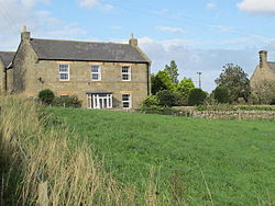
Harlow Hill is a small village in the civil parish of Stamfordham, in Northumberland, England. Harlow Hill lies on the line of Hadrian's Wall, and is the site of Milecastle 16. The Military Road also passes by the village. Harlow Hill was historically a township in the ancient parish of Ovingham. It became a separate civil parish in 1866. The civil parish was abolished on 1 April 1955, when it was merged with other parishes to create the civil parish of Stamfordham. In 1951 the parish had a population of 61.
Nearby Places View Menu
52 m
Milecastle 16
Milecastle 16 (Harlow Hill) was a milecastle of the Roman Hadrian's Wall. The milecastle is located at Harlow Hill, Northumberland, England. There are no visible surface remains of the milecastle or either of its associated turrets.

1.0 km
Albemarle Barracks, England
Albemarle Barracks is a British Army barracks located 1.7 miles (2.7 km) south of Stamfordham, Northumberland and 10.5 miles (16.9 km) west of Newcastle-upon-Tyne, Tyne and Wear.

1.2 km
North East England
North East England, often referred to as simply the North East within England, is one of nine official regions of England. It consists of County Durham, Northumberland, Tyne and Wear and part of North Yorkshire. With 2.6 million residents in 2022, it is the least populous region of England. Its largest settlements include Newcastle upon Tyne, Sunderland, Middlesbrough, Gateshead, Darlington and Hartlepool. The North East is covered by two mayoral combined authorities: North East Combined Authority and Tees Valley Combined Authority. It is one of three regions, the other two being North West England and Yorkshire and the Humber, that make up Northern England.

1.3 km
Whittle Dene
Whittle Dene is 12 miles (19 km) west of Newcastle upon Tyne, England, straddling the B6318 Military Road, and is a complex of reservoirs and treatment works forming the last stage in the supply of drinking water to Newcastle upon Tyne and Gateshead.