
 English
 Français
Firth of Clyde
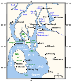
Le Firth of Clyde (en gaélique écossais : Linne Chluaidh) constitue une vaste étendue d'eau côtière du Royaume-Uni, abritée de l'océan Atlantique par la péninsule de Kintyre, qui renferme le firth extérieur d'Argyll et Ayrshire en Écosse. Sa partie supérieure inclut une vaste surface à la jonction du Loch Long et du Gare Loch. Elle est séparée de l'estuaire de la Clyde par un banc de sable, bien que la Clyde soit encore large à cet endroit et que sa plus haute limite de marée soit dans le centre de la ville de Glasgow. La vaste zone de mouillage de Greenock est connue sous le nom de Tail of the Bank, en référence à ce banc de sable.
Nearby Places View Menu
1.5 km
Firth of Clyde
The Firth of Clyde is the estuary of the River Clyde, on the west coast of Scotland. The Firth has some of the deepest coastal waters of the British Isles and is sheltered from the Atlantic Ocean by the Kintyre Peninsula. The Firth lies between West Dunbartonshire in the north, Argyll and Bute in the west, and Inverclyde, North Ayrshire and South Ayrshire in the east. Kilbrannan Sound is a large arm of the Firth, separating the Kintyre Peninsula from the Isle of Arran. The Kyles of Bute separates the Isle of Bute from the Cowal Peninsula. The Sound of Bute separates the islands of Bute and Arran.
The Highland Boundary Fault crosses the Firth. The Firth also played a vital military role during World War II.
The Firth is sometimes called the Clyde Waters or Clyde Sea. It is customarily considered to be part of the Irish Sea.

5.7 km
Glencallum Bay Lighthouse
Glencallum Bay Lighthouse is a lighthouse on a point on the northernmost side of Glencallum Bay on the Isle of Bute. Its Gaelic name is the Rubh' An Eun which means the point of the birds.
The lighthouse was built in 1911 by the Stevenson family business which built many of the lighthouses in Scotland.
It is on the West Island Way.

5.8 km
Little Cumbrae
Little Cumbrae (Scottish Gaelic: Cumaradh Beag) is an island in the Firth of Clyde, in North Ayrshire, Scotland. It lies south of Great Cumbrae, its larger neighbour. The underlying geology is igneous with limited outcrops of sedimentary rock. Little Cumbrae House is of 20th century construction, although the island has no permanent inhabitation at present, its population having peaked at 23 in the late 19th century. There is a lighthouse on the western coast.

6.2 km
Strathclyde
Strathclyde (Ystrad Clud in Welsh; Srath Chluaidh [s̪t̪ɾa ˈxl̪ˠɯi] in Gaelic, meaning 'strath [valley] of the River Clyde') was one of nine former local government regions of Scotland created in 1975 by the Local Government (Scotland) Act 1973 and abolished in 1996 by the Local Government etc. (Scotland) Act 1994. The Strathclyde region had 19 districts. The region was named after the early medieval Kingdom of Strathclyde centred on Govan, but covered a broader geographic area than its namesake by including Argyll and various Western islands in addition to its Southwestern core.

6.3 km
Castle Island, Scotland
Castle Island (Scottish Gaelic: Eilean a' Chaisteil) or Allimturrail is a small tidal island, lying off the east coast of Little Cumbrae, and to the west of Trail Island, in the Firth of Clyde. It is joined to Little Cumbrae at low tide.
The castle which gives the island its name was built in 1527, and was destroyed by Cromwellian forces in 1650. It is a square keep, and is said to have been built originally to prevent deer poaching.