
 English
 Français

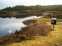
Daill Loch
Daill Loch is an impounding reservoir located 5 kilometres (3.1 mi) west north west of Lochgilphead and 1.5 kilometres (0.93 mi) south of the Crinan Canal. It is one of a number of lochs supplying water to the canal. The earthen dam is 8.1 metres (27 ft) high and was completed in 1930.
Nearby Places View Menu

1.4 km
Loch an Add
Loch an Add is a reservoir in Argyll, Scotland, roughly 3 km southwest of the village of Cairnbaan and 6 km west of the larger settlement of Lochgilphead. It is roughly 1 mile (1.6 km) long and up to 280 metres wide, and is longitudinal in a SW/NE orientation, occupying one several small parallel valleys between successive ridges (a geological formation closely resembling that of Anglesey) in an area of coniferous forest.
It is not to be confused with Lochan Add, a smaller body of water with roughly the same shape and orientation, but situated about 20 km to the north-east. Furthermore, neither of these two lochs is connected to the River Add, mentioned below.
The loch is one of several reservoirs within the Glen Clachaig Feeder System that supplies water to the Crinan Canal. It is maintained by an earthen dam at its north end, and is currently managed by Scottish Canals. Immediately downstream of this dam is another reservoir, Daill Loch, which is drained by the Dunardy Burn into the Crinan Canal.
Loch an Add was first named in 1814 by Scottish engineer Hugh Baird, designer of the Crinan and Union Canals. Baird's toponymy is unclear. One explanation is that it derives from the same Scottish Gaelic root as the River Add, àd or fhàd, which is a lenited form of fada meaning "long" i.e. "Long Loch". Another explanation is that Add is an Anglicisation of àth, meaning "ford" i.e. "Loch of the Ford".
The loch has a large stock of brown trout.

1.5 km
Loch a' Bharain
Loch a' Bharain (the Baron's Loch) is an impounding reservoir in Scotland.
Loch a' Bharain directly sits on the north bank of the Crinan Canal beside lock no.9, 1.5 kilometres (0.93 mi) west of Cairnbaan, and acts as a side pound to the summit reach: effectively increasing the area and therefore reducing the level changes caused by downward lockings at either end.
The earth-fill dam is 5.6 metres (18 ft) high and was constructed in 1801 during the construction of the Crinan Canal. Works were completed by 1810 and after further repair and inspection by 1815–1820 the Crinan canal helped bring jobs and industry to the area shortening what would be a longer voyage on boat to get to Crinan and other areas on the west coast. The 9 mile canal became known as a Royal Route when Queen Victoria sailed the canal after works completed, this was part of her tour of Scotland.
Loch á Bharain is one of the many many lochs (lakes) and burns (rivers) feeding the Crinan Canal. When the Crinan Canal was drained for repair and inspection in 2020–2021, Loch á Bharain was mostly drained, revealing old lock gates, tyres and other bits and pieces as well as the remains (floor plan) of the old castle of Clan McTavish.
The loch is regularly used by Mid Argyll Radio Sailing for model boats.

1.6 km
Gleann Loch
The loch runs south west to north east and is an impounding reservoir located to the west of Lochgilphead, Scotland. It is one of a number of lochs supplying water to the Crinan Canal. The earthen dam is 15 metres high. Records show the dam was constructed before 1860.
2.4 km
Cam Loch
Cam Loch (the Crooked Loch) is one of a number of water supply sources for the Crinan Canal. The impounding reservoir lies to the south of the canal and about 3 kilometres west of Lochgilphead. It has an earthwork dam 8.5 metres high, with records showing that construction was before 1860.