
 English
 Français

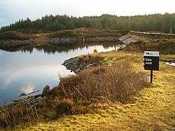
Gleann Loch
The loch runs south west to north east and is an impounding reservoir located to the west of Lochgilphead, Scotland. It is one of a number of lochs supplying water to the Crinan Canal. The earthen dam is 15 metres high. Records show the dam was constructed before 1860.
Nearby Places View Menu
833 m
Cam Loch
Cam Loch (the Crooked Loch) is one of a number of water supply sources for the Crinan Canal. The impounding reservoir lies to the south of the canal and about 3 kilometres west of Lochgilphead. It has an earthwork dam 8.5 metres high, with records showing that construction was before 1860.

1.4 km
Loch an Add
Loch an Add is a reservoir in Argyll, Scotland, roughly 3 km southwest of the village of Cairnbaan and 6 km west of the larger settlement of Lochgilphead. It is roughly 1 mile (1.6 km) long and up to 280 metres wide, and is longitudinal in a SW/NE orientation, occupying one several small parallel valleys between successive ridges (a geological formation closely resembling that of Anglesey) in an area of coniferous forest.
It is not to be confused with Lochan Add, a smaller body of water with roughly the same shape and orientation, but situated about 20 km to the north-east. Furthermore, neither of these two lochs is connected to the River Add, mentioned below.
The loch is one of several reservoirs within the Glen Clachaig Feeder System that supplies water to the Crinan Canal. It is maintained by an earthen dam at its north end, and is currently managed by Scottish Canals. Immediately downstream of this dam is another reservoir, Daill Loch, which is drained by the Dunardy Burn into the Crinan Canal.
Loch an Add was first named in 1814 by Scottish engineer Hugh Baird, designer of the Crinan and Union Canals. Baird's toponymy is unclear. One explanation is that it derives from the same Scottish Gaelic root as the River Add, àd or fhàd, which is a lenited form of fada meaning "long" i.e. "Long Loch". Another explanation is that Add is an Anglicisation of àth, meaning "ford" i.e. "Loch of the Ford".
The loch has a large stock of brown trout.

1.6 km
Daill Loch
Daill Loch is an impounding reservoir located 5 kilometres (3.1 mi) west north west of Lochgilphead and 1.5 kilometres (0.93 mi) south of the Crinan Canal. It is one of a number of lochs supplying water to the canal. The earthen dam is 8.1 metres (27 ft) high and was completed in 1930.

2.2 km
Knapdale
Knapdale (Scottish Gaelic: Cnapadal, IPA: [ˈkɾaʰpət̪əl̪ˠ]) forms a rural district of Argyll and Bute in the Scottish Highlands, adjoining Kintyre to the south, and divided from the rest of Argyll to the north by the Crinan Canal. It includes two parishes, North Knapdale and South Knapdale. The area is bounded by sea to the east and west (Loch Fyne and the Sound of Jura respectively), whilst the sea loch of West Loch Tarbert almost completely cuts off the area from Kintyre to the south. The name is derived from two Gaelic elements: Cnap meaning hill and Dall meaning field.
Knapdale gives its name to the Knapdale National Scenic Area, one of the forty national scenic areas in Scotland, which are defined so as to identify areas of exceptional scenery and to ensure their protection from inappropriate development. The designated area covers 32,832 hectares (81,130 acres) in total, of which 20,821 hectares (51,450 acres) is on land and 12,011 hectares (29,680 acres) is marine (i.e. below low tide level).