Location Image

Oxenber and Wharfe Woods

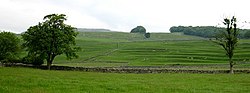
Oxenber and Wharfe Woods is a Site of Special Scientific Interest (SSSI) within Yorkshire Dales National Park in North Yorkshire, England. It is located 550 yards (500 m) north-west of the hamlet of Feizor. This area is protected because of the plant diversity found across the habitats present that include woodland, grassland and limestone pavement. Grazing has led to the woodland being classified as wood-pasture. This protected area comprises three named woodlands: Oxenber Wood, Wharfe Wood and Feizor Wood. Plant species within the woodland habitats vary between different soil types present in this protected area. On limestone soils, tree species include ash, hazel, hawthorn and rowan; and herbaceous plant species include dog's mercury, wood sorrel, wild thyme, salad burnet and spurge laurel. On acidic soils, tree species include birch and holly and understorey plant species include bilberry, wood anemone and heath bedstraw. Plant species within the limestone pavement include lesser meadow-rue, northern bedstraw and bloody cranes-bill. Within the northern section of Wharfe Wood there is marsh habitat where plant species include marsh marigold, bog asphodel, marsh arrowgrass and marsh valerian.

Nearby Places View Menu
Location Image
1.1 km

Feizor

Feizor is a hamlet in the Yorkshire Dales National Park, England.
Location Image
1.1 km

Wharfe, North Yorkshire

Wharfe is a hamlet about a mile north east of the village of Austwick, North Yorkshire, England. Its postcode is LA2 8DQ. The name means 'The bend', The hamlet is the only settlement in Crummackdale, the upper valley of Austwick Beck. Austwick Beck, which runs through Wharfe, flows into the River Wenning which in turn flows into the River Lune. Moughton Fell rises immediately behind the hamlet to a height of 1,400 ft (430 m). The upper plateau of Moughton is contained within 856 acres (3.46 km2) of common land with grazing rights (known as sheep gaits). The hamlet is within the boundary of the Yorkshire Dales National Park and is close to the Norber erratics, a group of boulders moved by glaciers during the last ice age. There were families with the name of Wharfe dating back to at least the 15th century living in the areas between Malham and Austwick, including the hamlet of Wharfe. In the 1379 poll tax Wharfe appears as querf and qwerf. In 2014 there are 14 dwellings. 11 are occupied, 2 are holiday homes and 1 is being refurbished. The current permanent population is 30 (21 adults, 9 children) 3 households are pensioner households (4 adults). In 2009 there were 12 dwellings, of which 10 were currently occupied. The population was 26 (20 adults and 6 children). 3 of the occupied households (6 adults) were pensioner households. In 1967 there were nine dwellings of which seven were occupied, including three working farms. The population was 16 (10 adults and 6 children). 3 of the occupied households (4 adults) were pensioner households. Of the three working farms, both Wharfe House Farm (94 acres) and Fleet House Farm ceased farming operations in 1967, and Low House Farm (147 acres plus 24 acres (97,000 m2) added since 1967) ceased operations in 2000. The 1901 census shows that there were 8 dwellings, 7 occupied. There was a population of 37 (21 adults and 16 children). In 1871 there were 8 households with a population of 35. The 1841 census shows 11 households, with a population of 36 (29 adults and 7 children) with an average age of 36 years.
Location Image
1.5 km

Austwick Hall

Austwick Hall is an historic manor house situated above the village of Austwick in North Yorkshire, England. The house is a Grade II listed building and contains a collection of furniture, paintings and ethnographic art. The gardens and woodland also contain a collection of contemporary sculptures. Austwick Hall is open to the public from the beginning of April to the end of October and takes guests for bed and breakfast throughout the year.
Location Image
1.6 km

Austwick

Austwick is a village and civil parish in North Yorkshire, England, about 5 miles (8 km) north-west of Settle. The village is on the edge of the Yorkshire Dales National Park. Before local government reorganisation in 1974, Austwick parish was within Settle Rural District which was in the county of the West Riding of Yorkshire. From 1974 to 2023 it was part of the district of Craven, it is now administered by the unitary North Yorkshire Council. According to the Austwick & Lawkland Tithe Map of 21 October 1851 the parish has an area of 8,201 acres (33.19 km2) of which around a quarter is uncut moorland. The highest point within the parish is at Lord's Seat on Simon Fell at 2,079 feet (634 m).