
 English
 Français
Ettrick Bay
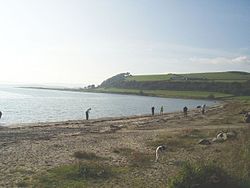
Ettrick Bay is a wide, tidal, sandy coastal embayment with a chord of 1 mile (2 km), on a 218° bearing, located on the west coast of the Isle of Bute in the Firth of Clyde, within council area of Argyll and Bute in Scotland. The bay was used for practice training for the D-Day landings.
Lieux à Proximité Voir Menu

2.4 km
St Colmac Manse
St Colmac Manse (also known as Cnoc an Raer) is a historic building in St Colmac on the Isle of Bute, Scotland. Dating to around 1835, it was the clergy house for the now-ruined and Category C listed St Colmac's Church, located about 600 feet (180 m) to the east, built around the same time. Both properties are believed to have been built by John Paterson, a "very able builder and skilled mason" of Largs.
The manse sits back about 250 feet (76 m) from the northern side of the B875 road, and several feet above it, at the end of a long driveway. It is two storeys, with a rear extension added in the 20th century. Also at the rear there are two stone outbuildings under slate roofs. The property sits on 1.79 acres (0.72 ha).

2.6 km
St Colmac's Church
St Colmac's Church is a ruined 19th-century church in St Colmac, north-east of Ettrick Bay, on the Isle of Bute, Argyll and Bute, Scotland. Built in 1835, it is now a Category B listed structure, as are its kirkyard, boundary wall, gatepiers and gates.
What is now known as Cnoc an Raer, the former manse of the church, is located about 600 feet (180 m) to the west, built around the same time. Both properties are believed to have been built by John Paterson, a "very able builder and skilled mason" of Largs. They stand on the northern side of the B875 road, the church in a triangular plot of land with a minor road bounding it on its northern side.
Now gutted, the church's interior had an "unusual" arrangement, per photographs in the possession of the National Monuments Record of Scotland, with a full-length common communion table running east-to-west down the centre of the church, flanked by timber pews. West-facing box pews lined the side aisles. According to the handbook of the Scottish Vernacular Buildings Working Group, the communion table was made when required by converting pew ends.
3.0 km
Isle of Bute
The Isle of Bute (Scots: Buit; Scottish Gaelic: Eilean Bhòid or An t-Eilean Bòdach), known as Bute (), is an island in the Firth of Clyde in Scotland. It is divided into highland and lowland areas by the Highland Boundary Fault.
Formerly a constituent island of the larger County of Bute, it is now part of the council area of Argyll and Bute. Bute's resident population was 6,498 in 2011, a decline of just over 10% from the figure of 7,228 recorded in 2001 against a background of Scottish island populations as a whole growing by 4% to 103,702 for the same period.

3.7 km
Wester Kames Castle
Wester Kames Castle is located near Kames Bay near Port Bannatyne, Isle of Bute, Scotland. Dating from around 1700, the castle was rebuilt around 1900 from a ruined state.