
 English
 Français

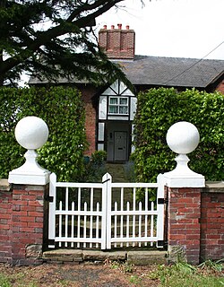
Hankelow Hall
Hankelow Hall is a former country house to the north of the village of Hankelow, Cheshire, England.
Nearby Places View Menu
607 m
Ball Farm
Ball Farm is the oldest surviving building in the village of Hankelow, near Audlem in Cheshire, England, and is thought to date from 1510. Most of its original timber frame was replaced by brick in the 19th century, but some close studding and small framing survives, as well as part of a mullioned-and-transomed window. Ball Farm was occupied by the Hassalls, a prominent local family, and might have once been used as a district court of justice. It is listed at grade II* by the Historic Buildings and Monuments Commission for England, the middle of the three grades, denoting "particularly important buildings of more than special interest".

829 m
Hankelow
Hankelow is a village and civil parish in the unitary authority of Cheshire East and the ceremonial county of Cheshire, England. The village lies on the A529, around 1.25 miles (2.0 km) north east of Audlem and 4.5 miles (7.2 km) south of Nantwich. The civil parish has an area 369 hectares (910 acres) and also includes the small settlement of The Dell and part of Corbrook, with a total population of just over 260 in 2011. Nearby villages include Aston, Broomhall Green, Sound, Hatherton and Buerton in Cheshire and Woore in Shropshire.
Hankelow is first documented in the 13th century, and the village historically had a school, two chapels, two public houses, a water mill, post office, shop and other facilities. Only a Methodist chapel – also used as a community centre – remained open in 2020. Two buildings are listed at grade II*: the 16th-century Ball Farmhouse and the 18th-century Hankelow Hall. Outside the village, the civil parish is predominantly rural and agricultural. The River Weaver runs in the west of the parish, and there is a small area of probable ancient woodland in the north east.

1.3 km
Coole Pilate
Coole Pilate is a civil parish in the unitary authority of Cheshire East and the ceremonial county of Cheshire, England, which lies to the north of Audlem and to the south of Nantwich. The area is predominantly rural with scattered farms, and a total population of 60 people. At the 2011 Census the population remained less than 100. Details are included in the civil parish of Austerson. Nearby villages include Broomhall Green, Hankelow, Hatherton and Newhall.

1.8 km
Little Heath, Cheshire East
Little Heath is a village in the civil parish of Audlem, Cheshire, England. It is located to the north of Audlem, between Lonk Land and Audlem Road, the latter being part of today's A529 road.