
 English
 Français

Milbourne is a village and former civil parish 14 miles (23 km) from Morpeth, now in the parish of Ponteland, in the county of Northumberland, England. In 1951 the parish had a population of 70. Milbourne has a church called Holy Saviour.
Nearby Places View Menu

0 m
Scrainwood
Scrainwood is a hamlet and former civil parish 20 miles (32 km) from Morpeth, now in the parish of Alnham, in the county of Northumberland, England. In 1951 the parish had a population of 16. Scrainwood Estate is 1048 acres and has a shoot that specializes in partridges.
1.5 km
Alnham
Alnham (, ) is a hamlet and civil parish in Northumberland, England. It is about 14 miles (23 km) west of Alnwick, and is about 6 miles (10 km) from the Scottish border, on the south of a small tributary of the River Aln. The village stands on uneven ground, sloping from south to north, at the foot of the southern outliers of the Cheviot Hills. The River Aln flows eastward through the village from its source in the Cheviot Hills down to the coast. The layout of the village appears to have been dictated by the river. The estimated population taken at the 2011 Census was around 245.
There is evidence of human occupation in Alnham and the surrounding areas dating from prehistoric times. The remains of a medieval settlement, hillforts, and other historic buildings can still be found in the village today. Due to its location, Alnham often suffered in the Anglo-Scottish border conflict during its history. The economy of Alnham has been focused on agriculture throughout its existence as a settlement.
1.5 km
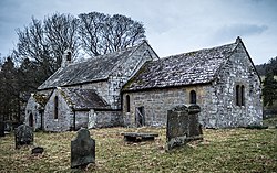
Church of St Michael, Alnham
The Church of St Michael in Alnham, in the English county of Northumberland, is a medieval structure dating from circa 1200. Built on a Roman camp site, it is mentioned in records dating to 1291; it is a Grade I listed building.

1.9 km
Netherton, Northumberland
Netherton is a village and civil parish in the English county of Northumberland. The population of the village at the 2011 census was 185.
Located 6+1⁄2 miles (10.5 km) northwest of the town of Rothbury Netherton is close to the Anglo-Scottish border. Historically it was part of the parish of Alwinton of which it formed the townships of Netherton Northside and Netherton Southside. Also in the civil parish are the settlements of Netherton Burnfoot at grid reference NT995072 and Burradon at NT981061.
The village's public house, the Star Inn, has its interior included in the National Inventory of Historic Pub Interiors by CAMRA. It was listed in the first 40 editions of the CAMRA Good Beer Guide from 1974 until 2013, being one of only 7 pubs to achieve this.
There is a First School (Now Closed).