
 English
 Français

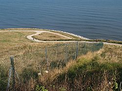
Knipe Point
Knipe Point (or Osgodby Point) is a rocky headland on the North Sea coast, between Cornelian Bay and Cayton Bay in North Yorkshire, England. From this point, and running south, is the steeply sloping clay-till cliff on top of which stood the NALGO holiday camp between 1933 and 1974; this is where Knipe Point Drive was later built. The Cayton Cliff is subject to continuing surface landslips, potentially major at times, such as the one of 2008, known as the Knipe Point Landslide, which received national media attention due to the loss of three homes.
Nearby Places View Menu

589 m
Cornelian Bay, North Yorkshire
Cornelian Bay is a bay of the North Sea near Scarborough, North Yorkshire, England. It is located between the headlands of White Nab and Knipe Point, just north of Cayton Bay. Geographical features of note include two Second World War pillboxes.
Public access can be had from the steep lane leading from the Yorkshire Water pumping station, just off the A165 Filey Road. The Cleveland Way skirts the clifftop for the length of the bay.
The bay is named after the semi-precious stone carnelian, examples of which are occasionally found washed up on the shore.

1.1 km
Osgodby, coastal North Yorkshire
Osgodby is a village and civil parish in the district and county of North Yorkshire, England.
Approximately 3 miles (4.8 km) south of Scarborough off the coastal road, Osgodby was a medieval village with a manor house mentioned in the Domesday Book as Asgozbi ('Asgaut's farm or estate'). It appears to have grown until the 13th or 14th century and then declined to a sparsely populated farming area by the 19th century. Housing was developed east of the medieval site in the 1930s and again from the 1960s, with buildings of farms on the site of the manor house being converted into a pub and a restaurant. The oldest surviving building is Stuart House, dated 1615. Remnants of a 13th-century chantry chapel of St Leonard have been incorporated into a barn.
According to the 2011 UK census, Osgodby parish had a population of 1,248, an increase on the 2001 UK census figure of 1,186.
From 1974 to 2023 it was part of the Borough of Scarborough, it is now administered by the unitary North Yorkshire Council.
2.2 km
Holbeck Hall Hotel
The Holbeck Hall Hotel was a clifftop hotel in Scarborough, North Yorkshire, England, owned by the Turner family. It was built in 1879 by George Alderson Smith as a private residence, and was later converted to a hotel.
On 4 June 1993, 55 metres (180 ft) of the 70 metres (230 ft) hotel garden had disappeared from view, the beginning of a landslide which gradually became more severe. The landslip was first reported to the police, early in the morning, 4 June, by Peter Swales, who took an early morning walk on South Cliff putting green and noted the hotel was at risk of collapsing. He went straight to the police station and reported that the guests were in imminent danger.
Finally on 5 June 1993, after a day of heavy rain, parts of the building collapsed, making news around the world. The hotel's chimney stack collapsed live on television just as Yorkshire TV's Calendar regional news programme went on air covering the building's precarious condition. Richard Whiteley was presenting the item at the time of the collapse. The remainder of the building was demolished for safety reasons. One of the likely contributing causes of the landslide was the substantial rain in the two months before it occurred. The mud flow from the landslide protruded 135 metres (443 ft) beyond the high-water mark.
Landslides are a common problem in Scarborough and along the coast from Filey to Whitby.
In 1997, the hotel's collapse became the subject of a significant court case in English civil law (Holbeck Hall Hotel Ltd v Scarborough BC) when the owners of the hotel attempted to sue Scarborough Borough Council for damages, alleging that as owners of the shoreline they had not taken any practical measures at all to prevent the landslip – from soft, to hard engineering, nothing was done. The claim was rejected on the grounds that the council was not liable for the causes of the slip because it was not reasonably foreseeable. Reasonable foreseeability is a requirement for liability in negligence and nuisance in English and Welsh tort law.

2.2 km
St John the Baptist's Church, Cayton
St John the Baptist's Church is the parish church of Cayton, a village in North Yorkshire, in England.
The church was constructed in the 12th century, from which period the chancel, north aisle, and part of the nave date. In the 15th century, the nave was extended, and a tower and north chapel were added. There was at one time a vault, which has since been filled in. In 1947, a clock was installed on the tower, celebrating that it was believed to be one of the doubly Thankful Villages. The church was Grade I listed in 1967.
The church is built of sandstone with a Welsh slate roof, and consists of a nave, a north aisle, a south porch, a chancel with a north chapel and vestry, and a west tower. The tower has three stages, diagonal buttresses, two-light flat-topped bell openings, and an embattled parapet with corner pinnacles. The gabled porch contains a round-arched Norman doorway that has two orders of shafts with scalloped capitals, and the arch with chevron decoration.
Inside the church is a slightly pointed 12th-century arcade, and a 12th-century font on a 19th-century base. The wooden door and doorframe to the tower date from 1678. There is a slab on the chancel floor with a brass inscription dating from 1452, and there are also some 18th-century monuments. There is an 18th-century charity board, and the oak communion table is 17th century.