
 English
 Français

Walgherton
Walgherton is a village and civil parish in the unitary authority of Cheshire East and the ceremonial county of Cheshire, England. The village lies at SJ697489 by the junction of the A51 and B5071 roads, 3½ miles to the south east of Nantwich and 4½ miles to the south of Crewe. The civil parish also includes the small settlement of Hussey's Nook. The total population is just under 130 people. Sand has been extracted at Hough Mill Quarry. The remainder of the parish is predominantly agricultural. Nearby villages include Hatherton, Stapeley and Wybunbury.
Nearby Places View Menu

900 m
Wybunbury
Wybunbury WIN-b(ə)ree or WIM-b(ə)ree is a village (at SJ698499) and civil parish in the unitary authority of Cheshire East and the ceremonial county of Cheshire, England. The village lies 3¼ miles to the south east of Nantwich and 3¾ miles to the south of Crewe. The parish also includes the settlements of Clannor Heath, Daisy Hill, The Flag, Pinfold and parts of Blakelow, Haymoor Green and Howbeck Bank. Nearby villages include Hough, Shavington, Stapeley and Walgherton. The A51 runs east–west through the south-western corner of the parish.
According to the 2001 census, the parish had a population of 1,474, reducing to 1,459 at the 2011 Census.
Wybunbury was listed in the Domesday Book as Wimeberie.

937 m
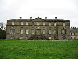
St Chad's Church, Wybunbury
Wybunbury Tower is what remains of the building formerly known as St Chad's Church in the village of Wybunbury, Cheshire, England. The body of the original church has been demolished but the tower still stands. The tower is recorded in the National Heritage List for England as a designated Grade II* listed building. The site of the tower is a Scheduled Monument. The current St Chad's Church is located in a modern building on a different site in the village.

1.2 km
Wybunbury Moss
Wybunbury Moss is a National Nature Reserve (NNR) and Site of Special Scientific Interest (SSSI) near the village of Wybunbury in Cheshire, England. It is a raised lowland bog, and a rare British example of a schwingmoor and a 'subsidence mire' (only two other British examples of the latter exist: Brookhouse Moss SSSI between Congleton and Sandbach, also in Cheshire, and Chartley Moss NNR in Staffordshire).
The site was first notified as an SSSI in 1951, and designated as an NNR in 1955, with further acquisitions added to the protected area in 1957 and 2009. It is owned and managed by Natural England.
1.5 km
Doddington, Cheshire
Doddington is a former civil parish, now in the parish of Doddington and District, in the unitary authority area of Cheshire East and the ceremonial county of Cheshire, England, which lies to the north east of Audlem and to the south of Crewe. Nearby villages include Blakenhall, Bridgemere, Checkley, Hatherton, Walgherton and Wybunbury. The A51 runs north–south through the parish.
In 2001, the civil parish had a population of 44. At the 2011 census the population remained less than 100. Details are included in the civil parish of Plumley.