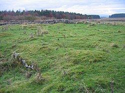
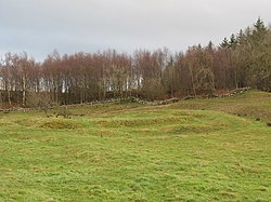
Limestone Corner is an area of Hadrian's Wall (and associated defences) at its most northerly point, in present-day northern England. It represents the most northerly point of the Roman Empire, outside the two periods during which the Antonine Wall was occupied by the Roman military. Other notable features at Limestone Corner are the wall ditch at this point, which was never completely excavated, a Roman camp and the site of Milecastle 30. Also present is a trig point. The B6318 Military Road also runs through Limestone Corner, as does the Military Way, serving Milecastle 30. The Military Way is visible on the ground at this point, the most eastern point where this is the case. The name "Limestone Corner" is accepted through extensive usage. It has no geographical status or appear on any official maps; the hill on which it stands is known as Teppermoor Hill.

Nearby Places View Menu
Location Image
49 m

Military Road (Northumberland)

The Military Road is part of the B6318 road in Northumberland, England, which runs from Heddon-on-the-Wall in the east to Greenhead in the west. For much of its length, the Military Road is straight and resembles a Roman road. However, the term "military road" comes from the impetus to build a road suitable for the movement of military equipment and vehicles between Newcastle and Carlisle. This was largely in response to the poor conditions encountered on the road by Hanoverian forces under Field Marshal Wade in 1746 when trying to suppress the Jacobites fighting for Bonnie Prince Charlie in the North. The struggle of the troops under Field Marshal Wade, and his association with other 'Military Roads' in Scotland, is likely to be the source of the claim that he was also responsible for this route. The road runs alongside Hadrian's Wall for much of its length, and long stretches of it are built on the foundations of the wall.
Location Image
130 m

Milecastle 30

Milecastle 30 (Limestone Corner) was a milecastle of the Roman Hadrian's Wall. Its remains exist as an outward-facing scarp with a maximum height of 0.8 metres (2.6 ft). Masonry from the east wall (both faces) remains in situ. The remaining stretch is 3.1 metres (10 ft) in length by 2.25 metres (7.4 ft) thick, and survives to a height of 0.6 metres (2.0 ft). It is located at the western part of Limestone Corner, just off the B6318 Military Road.
Location Image
1.3 km

Milecastle 29

Milecastle 29 (Tower Tye) was a milecastle of the Roman Hadrian's Wall. Its remains exist as a mutilated earth platform accentuated by deep robber-trenches around all sides, and are located beside the B6318 Military Road. Like Milecastles 9, 23, 25, and 51, a ditch has been identified around the Milecastle, and is still visible to a small extent. It has been postulated that this was as a result of the need for drainage on the site.
Location Image
1.8 km

Carrawburgh

Carrawburgh is a settlement in Northumberland. In Roman times, it was the site of a 3+1⁄2-acre (1.5 ha) auxiliary fort on Hadrian's Wall called Brocolitia, Procolita, or Brocolita. The name "Procolita" is found in the 5th-century document, the Notitia Dignitatum, and "Brocoliti" in the 7th-century Ravenna Cosmography. The name is probably based on the Celtic name for the place, and one possible translation put forward is 'badger holes'.