
 English
 Français
Lochinvar
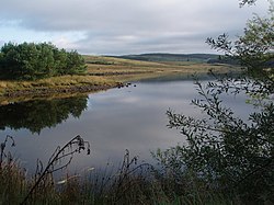
Lochinvar (or Lan Var) is a loch in the civil parish of Dalry in the historic county of Kirkcudbrightshire, Dumfries and Galloway Scotland. It is located in the Galloway Hills, around 3.5 miles (5.6 km) north-east of St. John's Town of Dalry. The loch formerly had an island on which stood Lochinvar Castle, seat of the Gordon family. In the 20th century the loch was dammed to form a reservoir, raising the water level and submerging the island with the ruins of the castle. The loch is used for trout fishing. The name Lochinvar is from Scots Gaelic Loch a' bharra (older Gaelic Loch an bharra, the genitive of barr = summit) meaning "Loch on the hilltop". Consequently, it is stressed on the last syllable (unlike Lochinver).
Nearby Places View Menu

4.2 km
Loch Howie
Loch Howie is a small, narrow, upland freshwater loch on the north side of Blackcraig Hill, approximately 18 miles (29 km) west of Dumfries, Scotland. The loch trends from south-west to north-east and is 0.75 mi (1.21 km) long by approximately 0.25 mi (0.40 km) at its widest point. It has an average depth of 16 ft (4.9 m) and is 39 ft (12 m) at its deepest. The loch was surveyed on 23 July 1903 by James Murray as part of Sir John Murray's Bathymetrical Survey of Fresh-Water Lochs of Scotland 1897-1909.
The loch is popular for fishing and is populated with perch, pike and roach.

4.6 km
Barscobe Castle
Barscobe Castle is a 17th-century tower house in Balmaclellan, Kirkcudbrightshire, Scotland. It is a typical house of a country laird, and according to a panel above the entrance, was built in 1648. The L-plan tower was constructed using stone taken from Threave Castle. Barscobe Castle is a category A listed building.

4.7 km
Earlstoun Castle
Earlstoun Castle, sometimes spelled Earlston Castle, is a derelict tower house near St John's Town of Dalry in Dumfries and Galloway, Scotland. Built in the late sixteenth century, it was home to members of the Gordon family, including William Gordon of Earlston who was killed at the battle of Bothwell Bridge. It is unusual for a tower house of its age for its lack of defensive arrangements: it has no gun loops, its roof is without a parapet or corner turrets, and it lies in open ground without natural defences.
The castle was designated a scheduled monument in 1937; it was also designated a Category A listed building in 1971, but was delisted in 2017, while retaining its scheduled monument status.

5.3 km
Loch Skae
Loch Skae is a small, upland freshwater loch to the north of Blackcraig Hill, approximately 18 miles (29 km) west of Dumfries, Scotland, 0.5 mi (0.80 km) east of Loch Howie, and 1 mi (1.6 km) south of the A702. The loch is somewhat circular in shape with a maximum diameter of 0.25 mi (0.40 km) from north to south. It has an average depth of 9.5 ft (2.9 m) and is 35 ft (11 m) at its deepest point. The loch was surveyed on 29 July 1903 by James Murray as part of Sir John Murray's Bathymetrical Survey of Fresh-Water Lochs of Scotland 1897-1909.