


Le pic de Bounèu (en espagnol pico de la Pala) est un sommet des Pyrénées, situé sur la frontière franco-espagnole entre les Hautes-Pyrénées, en région Occitanie, et la province de Huesca dans la communauté d'Aragon, qui culmine à 2 726 ou 2 723 mètres d'altitude dans le massif de la Munia.
Location

3.5 km
The Pic de la Munia culminating at 3,133 m is the highest point of the three cirques of Troumouse, Barroude and Barrosa. It is located on the border between France and Spain.

3.7 km
The Serre Mourene is a pyrenean summit, located on the Franco-Spanish border between the cirques of Troumouse and Barrosa, culminating at 3,090 m; it is the second highest summit of the massif de la Munia after the pic de la Munia.

4.0 km
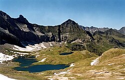
The Cirque d'Estaubé is a cirque in the central Pyrenees in the Pyrenees National Park, forming the frontier between France and Spain. The cirque lies 4 km to the east of its better known neighbour, the Cirque de Gavarnie, which is accessible via the Hourquette d'Alans; the Marboré valley is reached via the Brèche de Tuquerouye, where there is a small CAF hut.
The Gave d'Estaubé descends north from the cirque, first flowing into a small reservoir, the Barrage des Gloriettes, then into the main Héas valley.

4.1 km
Pic du Taillon or Pico Taillón is a summit in the Pyrenees, culminating at 3,144 m on the Franco-Spanish border in the Monte Perdido Range.
Pic du Taillon is considered one of the easiest 3,000ers above the Cirque de Gavarnie. Only the last part from the "finger" of the False Defile is a little steep, but the climb never technically difficult in the absence of snow. The panorama from the summit is grandiose, offering a view of the Monte Perdido Range, the Vignemale Range, the Néouvielle Range, Balaïtous and Pic du Midi de Bigorre on a clear day.
4.8 km
Lacs de Barroude are two lakes in Hautes-Pyrénées, France. At an elevation of 2355 m, the surface area of the largest is 0.094 km2.