
 English
 Français
Cameron Reservoir
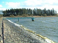
Cameron Reservoir is an artificial loch in the parish of Cameron in east Fife, Scotland. Covering an area of 43 hectares (110 acres), the reservoir is fed by a catchment of 558 hectares (1,380 acres) and its surface level is 146 metres (479 ft) above ordnance datum. Most of the catchment area is to the south and south-west of the loch.
Nearby Places View Menu

1.3 km
Cameron, Fife
Cameron is a parish in east Fife, Scotland, 3½ miles south-west of St Andrews.
It is bounded on the north by the parish of St Andrews, on the east by Dunino, on the south by Carnbee and Kilconquhar, and on the west by Ceres. From east to west it is 5 – 6 miles long and in breadth about 4 miles.
The earliest forms of the name are from the twelfth century and appear as Cambrun. The etymology of the name is uncertain: it may derive from Pictish, Scottish Gaelic, or be a Gaelicised Pictish name. The first element could thus be Gaelic cam or its Pictish cognate *cam (both meaning 'crooked'), and the second element could be a Pictish word *brun, cognate with Welsh bryn ('hill'), or Gaelic bruinne ('chest, front, breast') or perhaps brú ('belly'). The later development of the name was influenced by the widespread Scottish personal name Cameron (from Gaelic cam shròn 'crooked nose').
It contains the hamlets of Lathones, Denhead (first mentioned in 1581, from Scots den, 'steep valley', and heid, 'head or end', thus 'the end of the steep valley') and Radernie (first mentioned in 1329, from Gaelic ràth 'ring-fort' and an uncertain second element, possibly Gaelic àirne 'sloe', feàrnach 'alder', or Èirinn 'Ireland').
The civil parish has a population of 415 and its area is 9325 acres. It is also a Community Council area. The number of community councillors to which each area is entitled is determined by population and Cameron is therefore entitled to eight councillors.
Cameron was originally part of the parish of St Andrews, but was erected into a separate parish in 1645 by act of parliament and the first minister of the parish, George Nairne, was inducted in 1646. With the Local Government (Scotland) Act 1894 the Parish Council was established. It ceased in 1930 when parish councils in Scotland were abolished, but civil parishes persist for census and other non-administrative purposes.
The church is nearly in the centre of the parish, just north of Cameron Burn as its leaves Cameron Reservoir. It was built in 1808 to a plain design, replacing the old church on the same site which was in a very ruinous state. The church is covered in blue slate, with a belfry on the west gable. Ecclesiastically the parish is now linked to the parish of St. Leonards in the town of St Andrews, with the minister covering both churches.
The most significant mansion in the parish is that of Mount Melville, former residence of the Melville family, which lies just inside the northern boundary of the parish. It was acquired in 1698 for General George Melville of Strathkiness and the present house was constructed in 1820-1821. The house and grounds continued in Melville family ownership until 1901. In 1947 Mount Melville house and gardens were acquired by Fife County Council with the mansion becoming a maternity hospital known as Craigtoun Hospital. The gardens were then established as Craigtoun Country Park.
During the 19th century, the burgh of St Andrews implemented several poorly planned schemes to provide a public water supply to the town, but problems were resolved in 1911 when they built Cameron reservoir, in the centre of the parish, which supplied water to St Andrews from then until the early 2020s.

2.4 km
Peat Inn
Peat Inn is a hamlet in Fife, Scotland, around 7 miles (11 kilometres) southeast of Cupar on the B940 and 6 miles (10 kilometres) southwest of St Andrews, in the Riggin o Fife. The hamlet is centred on a Michelin starred restaurant with rooms after which the village takes its name.
2.7 km
Riggin o Fife
The Riggin o Fife is an upland area of Fife, Scotland which runs eastward from the Markinch Gap and the Howe of Fife to form the elevated hinterland to the coastal villages of the East Neuk. At 290 m, Largo Law is the highest hill, with other high points including Clatto Hill (248 m), Drumcarrow Craig (217 m), Flagstaff Hill (207 m), Kellie Law (182 m) and Hill of Tarvit (211 m). The area is rural, populated by farms and hamlets, with a few small villages, such as Largoward and Peat Inn.
Riggin denotes a high ridge, the roof, the backbone, the exposed parts or the watershed.
William Wilkie, agriculturalist and professor of natural philosophy at the University of St Andrews, conducted successful experiments in moorland farming at his farm at Cameron.
From 1898 to 1964, the Riggin was served by the East Fife Central Railway mineral and goods line.
The area lends its name to a pipe jig.

3.1 km
Craigtoun Miniature Railway
The Craigtoun Park Railway is a 15 in (381 mm) gauge railway operating on a circular track around part of the Craigtoun Country Park in St Andrews, Fife, Scotland.
The gauge employed is usually associated with more extensive railway operations, including public transport services on railways such as the Romney, Hythe and Dymchurch Railway in Kent, England. The Craigtoun Park Railway was originally introduced in 1960 as a 7+1⁄4 in (184 mm) gauge railway, but since 1976 it has been a 15 in (381 mm) gauge railway, and now operates on a circuit of approximately 400 yards (366 m), and purely as an attraction for families enjoying a day out in the public park owned by Fife Council and operated by the voluntary group The Friends of Craigtoun.
The rolling stock, all built by Severn Lamb, consists of two open and one semi-open toast-rack carriages, with motive power provided by a 2-8-0DH steam-outline locomotive built in 1973, designed to resemble a steam locomotive of the Denver and Rio Grande Western Railroad.