
 English
 Français
Lamaload Reservoir
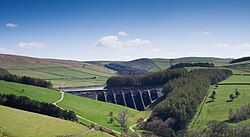
Lamaload Reservoir is a reservoir near Rainow, Cheshire, England (SJ972750). It lies in the South West Peak within the Peak District National Park, to the west of the Goyt Valley, and is fed by the River Dean. The reservoir is 0.93 km × 0.53 km, with a capacity of 1,909,000 m³, impounded by a multiple-arch, round-headed buttress dam in concrete, whose design was innovative at the time. It was built by Richard Costain Ltd in 1959–63 to serve Macclesfield, which lies to its west, and officially opened in 1965. The reservoir and associated water treatment works are owned by United Utilities. The area is a popular tourist spot, forming an access point for walkers to the surrounding moorland.
Nearby Places View Menu

2.0 km
Jenkin Chapel
Jenkin Chapel, stands in an isolated position on the western slopes of the Pennines, 4.3 miles (7 km) northeast of Macclesfield, Cheshire, England. It is recorded in the National Heritage List for England as a designated Grade II* listed building. The chapel lies at the junction of three ancient trackways, known as "salters' ways" because they were used by packhorses carrying salt. Later the tracks were used by cattle drovers and sheep dealers. It is an Anglican chapel in the diocese of Chester, the archdeaconry of Macclesfield and the deanery of Macclesfield. Its benefice is combined with those of Holy Trinity, Rainow and Forest Chapel, Macclesfield Forest.

2.3 km
Holy Trinity Church, Rainow
Holy Trinity Church is in the village of Rainow, Cheshire, England. It is an active Anglican parish church in the deanery of Macclesfield, the archdeaconry of Macclesfield, and the diocese of Chester. Its benefice is combined with those of St John, Saltersford, and St Stephen, Forest. The church is recorded in the National Heritage List for England as a designated Grade II listed building. It was a Commissioners' church, having received a grant towards its construction from the Church Building Commission.

2.4 km
Cats Tor
Cats Tor is a Peak District hill on the border between Cheshire and Derbyshire, between the towns of Macclesfield and Buxton. The summit is 518 metres (1,699 ft) above sea level. Tor is an Old English word for a high, rocky hill.
The higher peak of Shining Tor is about 2 km south along The Tors gritstone ridge. The ridge continues to the north past Windgather Rocks and Taxal Edge towards Whaley Bridge. On the west wide of the ridge, water drains into Todd Brook which feeds Toddbrook Reservoir. East of Cats Tor are views of the Goyt Valley, Foxlow Edge and Fernilee Reservoir.
The moorland ridge on which Cats Tor lies is designated "Open Access" land for the public, following the Countryside and Rights of Way Act 2000. The closest access is from Pym Chair car park, from where a public footpath, laid on large stone slabs, runs south across Cats Tor and continues south along the ridge to Shining Tor. A local legend tells that Pym Chair is the spot where a highway man called Pym robbed passers by on the packhorse route. Another story is that Pym was a preacher who gave sermons there.
The open gritstone moorlands of the Upper Goyt Valley (Wild Moor, Goyt's Moss, Burbage Edge, Shining Tor to Cats Tor ridge and Hop Moor) are a designated Site of Special Scientific Interest (SSSI). Heather is the main plant but the heathland is habitat for a variety of native grasses, rushes, sedges and shrubs including bilberry, crowberry, cowberry and cross-leaved heath. Hare’s-tail cottongrass and sphagnum moss are common along The Tors ridge. The area is important for upland breeding birds including a large population of golden plover, as well as red grouse, curlew, lapwing, whinchat, snipe, twite, ring ouzel and merlin.
On 30 September 1943 two Republic P-47D Thunderbolt planes crashed on Cats Tor. Both pilots were killed. The USAAF aircraft were from the 2906th Observation Group. The planes were on a training flight from RAF Atcham. Both aircraft flew straight into the hillside in cloud in the mid-afternoon.
Cats Tor is a popular location for paragliding, used by the Derbyshire Soaring Club and the Peak Soaring Association.
Oldgate Nick, on the northern slope of Cats Tor, is a gritstone buttress with 15 graded rock climbing routes.

2.5 km
Rainow
Rainow is a village and civil parish in Cheshire, England, in the valley of the River Dean and next to the B5470 road between Macclesfield and Kettleshulme. It straddles the eastern side of the Peak District border of Derbyshire and Cheshire, and is surrounded by pasture farmland. The Peak District Boundary Walk runs past the village. The village's name comes from the Old English hræfn + hōh, meaning "hill-spur frequented by ravens". It is a former mill village and has a population of around 2,500.
To the east of the village is Lamaload Reservoir, the first concrete reservoir constructed in England, between 1958 and 1964. At 308 metres (1,010 ft), it is also the highest constructed dam in England.
White Nancy, a circular, white-painted stone structure constructed to celebrate the anniversary of the Battle of Waterloo, stands at the northern end of Kerridge Hill on the boundary between the parishes of Rainow and Bollington.