
 English
 Français
Queen Elizabeth Hospital, Gateshead
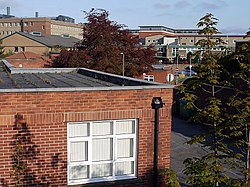
The Queen Elizabeth Hospital is based in Sheriff Hill in Gateshead, England. It is managed by Gateshead Health NHS Foundation Trust.
Nearby Places View Menu

345 m
Sheriff Hill
Sheriff Hill is a suburb in the Metropolitan Borough of Gateshead in Tyne and Wear, England. It lies on the B1296 road 2 miles (3 km) south of Gateshead, 2.5 miles (4 km) south of Newcastle upon Tyne and 12 miles (19 km) north of the historic city of Durham. According to the 2001 UK census it had a population of 5,051.
Historically part of Gateshead Fell in County Durham, Sheriff Hill was the site of a battle between William the Conqueror and Malcolm III of Scotland in 1068. A road was built through Gateshead Fell in the early 13th century, attracting some settlers. A procession of bishops, sheriffs and noblemen known as the Sheriff's March took place on the road in 1282, and continued biannually until the 1830s. By then, Gateshead Fell had been enclosed and a village had grown around the road, largely populated by an influx of tinkers, coalminers working at Sheriff Hill Colliery and workers at the local pottery, mill and sandstone quarry. By the turn of the 20th century these industries were in steep decline. The local authority built a large council estate at Sheriff Hill to alleviate dangerous overcrowding in Gateshead, effectively turning the area into a residential suburb. It ceased to be an independent village on 1 April 1974 when it was incorporated into the Metropolitan Borough of Gateshead under the terms of the Local Government Act 1972.
Now part of the local council ward of High Fell, the suburb is economically disadvantaged compared with other areas of the borough and nationally, with high levels of unemployment. Sheriff Hill was the site of one of Gateshead's largest boarding schools but as of 2012, the only remaining educational establishment is Glynwood Primary School. The suburb also contains the Queen Elizabeth Hospital – the largest hospital in Gateshead, a small dene and a small park. The principal landmark is St John the Evangelist Church, one of three Grade II listed buildings in the area and one of two remaining churches. The southern end of Sheriff's Highway – the main road through the suburb, is more than 500 feet (150 m) above sea level, making it the highest point in Gateshead.

511 m
St John's Church, Gateshead Fell
St John's Church, Gateshead Fell, is in Church Road, Sheriff Hill, Gateshead, Tyne and Wear, England. It is an active Anglican parish church in the deanery of Gateshead, the archdeaconry of Sunderland, and the diocese of Durham. The church is recorded in the National Heritage List for England as a designated Grade II listed building. It was a Commissioners' church, having received a grant towards its construction from the Church Building Commission. The church stands at the highest point in Gateshead.
563 m
Gateshead Fell
Gateshead Fell was a district in County Durham, England. It was located on the immediate border of the town of Gateshead, 2.3 miles from the city of Newcastle upon Tyne. Once described as a "dark, spongy moor", Gateshead Fell existed in some form for almost nine hundred years before it was enclosed in 1809 and divided into a number of villages, notably Sheriff Hill, Low Fell and Wrekenton, which were themselves absorbed by the urban expansion of Gateshead and were officially incorporated into the Metropolitan Borough of Gateshead with the passing of the Local Government Act in 1974.

636 m
Windy Nook
Windy Nook is an area in Tyne and Wear, England, bordered by Carr Hill to the west, Whitehills Estate and Leam Lane Estate to the east, Felling to the north and Sheriff Hill to the south. It lies on steep, sloping land 2.25 miles (3.62 km) south of Gateshead, 2.75 miles (4.43 km) south of Newcastle upon Tyne and 12 miles (19 km) north of Durham. In 2011, the Windy Nook and Whitehills ward had a population of 9,781. Formerly part of Heworth, it was incorporated into the newly formed Metropolitan Borough of Gateshead on 1 April 1974.
Windy Nook has a long industrial history, with evidence of milling and pottery in the area. The principal industry, however, was stone quarrying, and the initial settlement grew as this industry flourished. By the turn of the 19th century, several quarries operated in Windy Nook and the largest, Kell's Quarry, provided the sandstone and grindstone used to build St Alban's Church, a Grade II listed building and principal landmark in the village, which was consecrated on 25 August 1842.
The decline in industry in the 20th century saw the population fall to pre-industrial levels. Though today an urban suburb, there are no large commercial areas and the new Tesco store is the largest employer. There remains large areas of green space, however, and it is a popular and high-demand place to live. Residents compare favourably with others in the borough in terms of income, employment levels and educational qualifications.
Windy Nook Nature Reserve is a protected wildlife area, as well as one of the largest environmental sculptures in Europe. Mary Elizabeth Wilson, a serial killer, was known as The Merry Widow of Windy Nook. Joseph Hopper, founder of the aged mineworkers scheme, and John Oxberry, a prominent historian, also hailed from the village.