
 English
 Français

Kirkandrews-on-Esk
Kirkandrews-on-Esk est une paroisse civile de Cumbria, située dans le nord-ouest de l'Angleterre.
Nearby Places View Menu

1.4 km
Coop House, Netherby
Coop House, near Netherby in Cumbria, England, is a small building by the River Esk, erected about 1772 as part of a salmon fishery project, and restored in the 1990s by the Landmark Trust. It is a Grade II* listed building; it is described in the listing as a folly tower.

1.4 km
Longtown railway station
Longtown railway station served the town of Longtown, Cumbria, England, from 1861 to 1970 on the Waverley Route.
1.5 km
Kirkandrews on Esk
Kirkandrews, also known as Kirkandrews on Esk to distinguish it from Kirkandrews-on-Eden, is a civil parish in the Cumberland district of Cumbria, England. The main settlement in the parish is the hamlet of Moat. The parish lies immediately south of the border with Scotland. In medieval times, Kirkandrews formed part of the Debatable Lands claimed by both England and Scotland. Following a treaty in 1552, the Debatable Lands were partitioned between the two countries, and Scots' Dike built to mark the agreed border; it remains part of the boundary of Kirkandrews parish today. The parish straddles the River Esk. At the 2021 census, it had a population of 458.
1.9 km
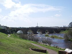
Longtown, Cumbria
Longtown is a market town in Cumbria, but in the historic county of Cumberland, England, just south of the Scottish Border. It has a sheep market which was at the centre of the 2001 United Kingdom foot-and-mouth crisis. Just south-west of Longtown is Arthuret Church, dedicated to Saint Michael and All Angels.

2.1 km
Scotch Dyke railway station
Scotch Dyke railway station was a railway station in Cumberland close to the Scots' Dike, the traditional border with Scotland.