
 English
 Français
Loch Arklet
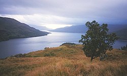
Loch Arklet is a freshwater loch and reservoir in the Trossachs area of the Scottish Highlands. It is within the historic county and registration county of Perthshire and the district of Stirling. It is situated to the east of Loch Lomond, with which it is connected by the Arklet Water. The western end of Loch Arklet was dammed between 1910 and 1915, raising the water level to provide Glasgow with fresh drinking water.
Nearby Places View Menu
531 m
Loch Lomond and The Trossachs National Park
Loch Lomond and The Trossachs National Park (Scottish Gaelic: Pàirc Nàiseanta Loch Laomainn is nan Tròisichean) is a national park in Scotland centred on Loch Lomond and the hills and glens of the Trossachs, along with several other ranges of hills. It was the first of the two national parks established by the Scottish Parliament in 2002, the second being the Cairngorms National Park. The park extends to cover much of the western part of the southern highlands, lying to the north of the Glasgow conurbation, and contains many mountains and lochs. It is the fourth-largest national park in the British Isles, with a total area of 1,865 km2 (720 sq mi) and a boundary of some 350 km (220 mi) in length. It features 21 Munros (including Ben Lomond, Ben Lui, Beinn Challuim, Ben More and two peaks called Ben Vorlich) and 20 Corbetts.
The park straddles the Highland Boundary Fault, which divides it into two distinct regions - lowland and highland - that differ in underlying geology, soil types and topography. The change in rock type can most clearly be seen at Loch Lomond itself, as the fault runs across the islands of Inchmurrin, Creinch, Torrinch and Inchcailloch and over the ridge of Conic Hill. To the south lie green fields and cultivated land; to the north, mountains.
The Loch Lomond and The Trossachs National Park lies close to Scotland's heavily populated Central Belt, and the area has long been popular with visitors. Principal attractions are viewing scenery and wildlife, walking, climbing, water sports, and other outdoor activities. In 2017, there were 2.9 million visits to the park, of which 2.1 million were day visits and 783,000 were made by visitors staying overnight within the park.

3.8 km
Inversnaid
Inversnaid (Scottish Gaelic: Inbhir Snàthaid) is a small rural community on the east bank of Loch Lomond in Scotland, near the north end of the loch. It has a pier and a hotel, and the West Highland Way passes through the area. A small passenger ferry runs from Inversnaid to Inveruglas on the opposite shore of the loch, and also to Tarbet. There is a seasonal ferry that also operates between Ardlui and Ardleish as well, which is a walkable distance from Inversnaid. To reach Inversnaid by road involves a 15-mile (24-kilometre) route from Aberfoyle. Nearby is an alleged hideout of Rob Roy MacGregor known as Rob Roy's Cave. The cave is difficult to access, and is best seen from Loch Lomond, where there is white paint indicating the location of the hideout.

3.9 km

4.6 km
Beinn a' Chòin
Beinn a' Choin (769 m) is a mountain in the Grampian Mountains of Scotland. It lies on the border of the Stirling region and Argyll at the northern end of Loch Lomond.
A rugged and wild mountain of rocks and moorland lying north of Ben Lomond, it usually climbed from the small settlement of Inversnaid.