
 English
 Français

Waren (port)
Waren, also known as Warn, Waren Bay, Warenmouth and Warenquay, was a seaport at Budle Bay, on the north-east coast of England. The recorded history of the port spans from the 1240s to the early twentieth century. Waren was England's northernmost mainland port during periods in which Berwick Upon Tweed was controlled by the Kingdom of Scotland. The port was associated with Bamburgh and its castle, situated 1.5 miles (2.4 km) to the east-south-east.
Nearby Places View Menu
977 m
Bamburgh Coast and Hills
Bamburgh Coast and Hills is the name given to a Site of Special Scientific Interest (SSSI) on the coast of north Northumberland, England. The site is one of the longest-standing SSSIs in England, having been listed since 1954, and displays the interaction of a fluid magma rock, now known as the Whin Sill, interacting with older sedimentary rock. Coastal erosion at the site enables sections of the geological strata to be seen. In turn, the soil associated with the Whin Sill gives rise to a distinct pattern of vegetation which on its own merits is at this site found notable.
1.1 km
Budle Bay
Budle Bay is a 1 mile (1.6 km) wide bay on the North Sea in Northumberland, England, between Bamburgh to the southeast and Lindisfarne to the northwest.
The bay is roughly square in plan opening to the North Sea along its northeastern side. Budle Point forms its eastern extremity. It is overlooked by Bamburgh Castle Golf Club at this point and by the Northumberland Coast Path and St Oswald's Way which share a common route in this vicinity. Waren Burn enters the bay at its southern corner whilst Ross Low, a smaller burn enters from the western corner. The two streams meet in the intertidal zone and continue east to the low water mark as Budle Water. The bay forms a part of the Lindisfarne National Nature Reserve. It is also a part of the Goswick-Holy Island-Budle Bay GCR site These are sites listed in the Geological Conservation Review as being of national importance; in this case for its coastal geomorphology.
It is underlain by limestone and other rock types of the Alston Formation though these are not exposed except along parts of its southeastern shore. The quartz-microgabbro of the Whin Sill occupies the higher ground on this southeastern side of the bay. There are extensive deposits of blown sand forming Ross Links at the opposite side of the bay and much of the bedrock on the southeastern side is obscured by similar dune deposits.
A seaport existed in Budle Bay up to the early twentieth century variously called Waren, Warenmouth and Warenquay.
1.8 km
Brada Hill
Brada Hill is a small hill escarpment near the coast of north Northumberland in North East England, designated as a Site of Special Scientific Interest (SSSI). The 2.4 hectares (5.9 acres) site is an outcropping of a local stone group, the Whin Sill, on which grows a range of flora representative of the thin, drought-prone soil conditions and influenced by the underlying geology.
2.0 km
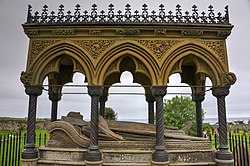
Monument to Grace Darling
The Monument to Grace Darling, in the churchyard of St Aidan's Church, Bamburgh, Northumberland is a Victorian Gothic memorial. The monument was designed by Anthony Salvin, with later renovations by Frederick Wilson, C. R. Smith and W. S. Hicks. Grace Darling was born on 24 November 1815, the daughter of the lighthouseman at Longstone Lighthouse. In 1838, Darling became a national heroine when she and her father rescued nine people from the wreck of the SS Forfarshire, a ship that had run aground off Big Harcar, an island off the Northumbrian coast. Darling died of tuberculosis aged 26 in 1842, and the monument was raised some distance to the north of her grave to make it visible to passing sailors, at the west edge of the churchyard in the same year. It is a Grade II* listed structure.