
 English
 Français
Red Street is a small, semi-rural village in the borough of Newcastle-under-Lyme, Staffordshire 6 miles (9.7 km) north west of Stoke-on-Trent, 2 miles (3.2 km) east of the neighbouring village of Audley and 1 mile (1.7 km) north of Chesterton. Local amenities include a pub, community centre, butchers shop, church and primary school.
Lieux à Proximité Voir Menu
797 m
Crackley
Crackley is an estate in the Borough of Newcastle-under-Lyme, Staffordshire. It is a former National Coal Board estate and lies on the edge of the larger village of Chesterton. It has a crossroads which links to park house industrial estate behind it which is next to Crackley Bank fields. The bank is an unusual main road that is directly connected to Red Street.
1.2 km
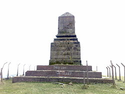
Bignall Hill
Bignall Hill, Staffordshire is a local landmark, and forms part of an escarpment ridge 4 miles (6.4 km) north-west of Newcastle-under-Lyme. It is classed as a sub HuMP. There is a large stone monument on the summit which is dedicated to John Wedgwood (1760–1839), a former local employer and coal mine owner. Wedgwood's monument was initially an obelisk erected in 1850. Following storm damage in 1976 it was reduced to a quarter of its original size, although the base is still substantial. The monument is a Grade II listed building. The monument is today reachable by footpaths, and is the highest point in the area. It affords sweeping 360-degree views: south to Cannock Chase and the city of Stoke-on-Trent; north across the Cheshire Plains to Jodrell Bank radio telescope; east to Mow Cop Castle and the Peak District; and west to the mountains of North Wales and Snowdonia.
Bignall Hill is in the parish of Audley Rural. Around the base of the hill are the hamlets of Bignall End, Red Street and Waterhayes.
1.4 km
Talke Pits
Talke Pits is a former mining village in the Borough of Newcastle-under-Lyme, Staffordshire, England, close to the Cheshire border and the village of Talke. Population details taken at the 2011 census can be found under Kidsgrove.
The nature reserve Parrot's Drumble is adjacent to the village.

1.4 km
Chesterton, Staffordshire
Chesterton is a former mining village on the edge of Newcastle-under-Lyme, in the Newcastle-under-Lyme district, in Staffordshire, England.
Chesterton is the second largest individual ward in the Borough of Newcastle-under-Lyme. In the 2011 census, Chesterton's population stood at 7,421.