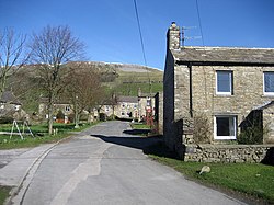
Sedbusk is a hamlet near Hawes and Hardraw Force within the Yorkshire Dales in North Yorkshire, England. The hamlet is 1 mile (1.5 km) north of the town of Hawes across the River Ure. Sedbusk is in the civil parish of High Abbotside along with Hardraw and Simonstone. The name of the hamlet derives from the Old Norse Saetr buskr, which means 'the bush by the shieling'. In 1280, it was recorded as setebuskste. From 1974 to 2023 it was part of the district of Richmondshire, it is now administered by the unitary North Yorkshire Council. Sedbusk is situated just off the "high road" in Wensleydale (the road on the opposite side of the valley to the A684). The road that goes through the hamlet is part of an old drovers road that is said to have been the route that Mary Queen of Scots travelled along on her way to Castle Bolton. The hamlet sits in the shadow of Stags Fell (to the north) which was formerly a centre of quarrying for stone and at one point even had a small colliery, though it is believed to have been only sourcing coal for lime burning. Stone produced at Stag Fell was Yoredale Sandstone and whilst production ceased in the 1930s, the tunnels cut into the hillside are still there and are dangerous to enter.

1. See also

Listed buildings in High Abbotside

1. References


1. External links
Nearby Places View Menu
Location Image
516 m

Stone House, Hawes

Stone House is a Grade II listed building near Hawes, North Yorkshire, England, in the civil parish of High Abbotside.
Location Image
1.3 km

Simonstone, North Yorkshire

Simonstone is a hamlet near Hawes and Hardraw Force within the Yorkshire Dales in North Yorkshire, England. The name is first recorded in 1301 as deriving from Sigemund's Rock. From 1974 to 2023 it was part of the district of Richmondshire, it is now administered by the unitary North Yorkshire Council. The road heading south from the Buttertubs Pass passes through the hamlet.
Location Image
1.4 km

Wensleydale

Wensleydale is a valley in North Yorkshire, England. It is one of the Yorkshire Dales, which are part of the Pennines. The dale is named after the village of Wensley, formerly the valley's market town. The principal river of the valley is the Ure, which is the source of the alternative name Yoredale. The majority of the dale is within the Yorkshire Dales National Park; the part below East Witton is within the national landscape of Nidderdale. Addlebrough, at 481 metres (1,578 feet), dominates the landscape of the upper dale, and Penhill, at 526 metres (1,726 feet), is prominent in the lower dale. The dale lends its name to the Yoredale Group of Carboniferous rocks. The dale is famous for its cheese, with the main commercial production at Hawes.
Location Image
1.5 km

Dales Countryside Museum

The Dales Countryside Museum is a local museum for the Yorkshire Dales National Park in Northern England. Run by the National Park Authority, it tells the story of the people who have lived and worked in the Yorkshire Dales for over a 1,000 years. The basis of the museum was a collection of artefacts gathered by Marie Hartley, Ella Pontefract and Joan Ingilby.