
 English
 Français
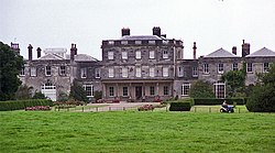
Birdsall House
Birdsall House is an English country house in Birdsall, North Yorkshire. It is a Grade II* listed building. The house dates from the late 16th century but was remodelled in 1749 with addition of second storey (third floor) to the main range. A wing was added in 1776 and a matching right wing added in 1872. It is constructed in ashlar with Welsh slate roofs. The central range is a 3-storey, 5-bay building connected to outlying 2-storey 2-bay side wings by single cell units. The house was the first house in England to benefit from a private gas system.
Nearby Places View Menu
526 m
Birdsall, North Yorkshire
Birdsall is a village and civil parish in North Yorkshire, England. According to the 2001 census it had a population of 180, increasing to 343 at the 2011 Census. The village is about four miles south of Malton and the parish also includes the village of North Grimston.
It was historically part of the East Riding of Yorkshire until 1974, between 1974 and 2023 it was part of the Ryedale district. It is now administered by the unitary North Yorkshire Council.

642 m
St Mary's Church, Birdsall
St Mary's Church is the parish church of Birdsall, North Yorkshire, a village in England.
St Mary's Church was first recorded in 1130. By the early 19th century, it was in poor repair. In 1824, it was demolished and rebuilt for Henry Willoughby, 6th Baron Middleton, to a design by James Pigott Pritchett and Charles Watson. Between 1879 and 1881, C. Hodgson Fowler added a chancel and an additional stage to the tower. The church was Grade II listed in 1966.
The Gothic revival church is built of limestone. It consists of a three-bay nave, with a boiler house to the north, a two-bay chancel with an organ chamber to the north, and a west tower. The tower has three stages, diagonal stepped buttresses, a semi-octagonal stair turret to the north, string courses, and an openwork parapet with octagonal corner turrets and finials. On the lowest stage is a window with a pointed head on the west side, and on the south side is a doorway with a pointed head, a hood mould with crockets, and a bas-relief with two figures and a coat of arms. In the middle stage are lancet windows, and above, the bell openings have three lights. Along the nave are pierced parapets. The east window has a five-light window, and below it is a door providing access to the crypt.
Inside the church are numerous memorials, including a 14th century recumbent figure of a woman, two black marble monuments from the late 17th century, a plaque to Thomas Southeby, designed by John Michael Rysbrack, and a white marble model of a kneeling woman, designed by Richard Westmacott. John Betjeman described the church as having "good modern glass".

2.3 km
Buckrose
Buckrose was a wapentake of the historic East Riding of Yorkshire, England consisting of the north-west part of the county; its territory is now partly in the modern East Riding and partly in North Yorkshire. Established in medieval times, it ceased to have much significance in the 19th century when the wapentakes were succeeded by other administrative divisions for most local government purposes. Buckrose was formed from parishes of earlier wapentakes, including some from the Domesday-era wapentake of Toreshou.
Buckrose consisted of the parishes of Acklam, Birdsall, Bugthorpe, Burythorpe, Cowlam, Fridaythorpe, Helperthorpe, Heslerton, Kirby Grindalythe, Kirby Underdale, Langton, North Grimston, Norton, Rillington, Scrayingham, Settrington, Sherburn, Skirpenbeck, Sledmere, Thorpe Bassett, Weaverthorpe, Westow, Wetwang, Wharram-le-Street, Wharram Percy, Wintringham and Yedingham. The only town in the wapentake was Norton.
Buckrose gave its name to a parliamentary constituency which existed from 1885 to 1950; however, the Buckrose constituency extended well beyond the boundaries of the wapentake, and in fact took most of its electorate from towns in the neighbouring Dickering and Harthill wapentakes.

2.4 km
Burythorpe
Burythorpe is a village and civil parish in North Yorkshire, England, about 4 miles (6 km) south of Malton. According to the 2001 census it had a population of 289, reducing marginally to 286 at the Census 2011. The Whitegrounds barrow is nearby.
It was historically part of the East Riding of Yorkshire until 1974, then between 1974 and 2023 was part of the Ryedale district. It is now administered by the unitary North Yorkshire Council.